Back ديسلي (تشيشير) Arabic ديسلى ARZ Disley (kapital sa distrito) CEB Disley Welsh Disley French Disley Italian Disley LLD Disley Dutch Disley Polish Disley Swedish
This article needs additional citations for verification. (April 2008) |
| Disley | |
|---|---|
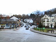
 Disley village centre | |
Location within Cheshire | |
| Population | 4,294 (2011) |
| OS grid reference | SJ972845 |
| • London | 186 miles (299 km) |
| Civil parish |
|
| Unitary authority | |
| Ceremonial county | |
| Region | |
| Country | England |
| Sovereign state | United Kingdom |
| Post town | STOCKPORT |
| Postcode district | SK12 |
| Dialling code | 01663 |
| Police | Cheshire |
| Fire | Cheshire |
| Ambulance | North West |
| UK Parliament | |
Disley is a village and civil parish in Cheshire, England.[1][2] It is located on the edge of the Peak District in the Goyt valley, south of Stockport and close to the county boundary with Derbyshire at New Mills. The population at the 2011 Census was 4,294.[3] To the north, the River Goyt and the Peak Forest Canal, which opened in 1800, pass along the edge of the village. Today, it is a dormitory village retaining a semi-rural character.
The parish includes part of the neighbouring village of Newtown, the bulk of which is in Derbyshire.[4]
- ^ The Parish of Disley (Official Guide). Disley Parish Council. 1994.
- ^ "Borough of Macclesfield: Parish Clerks". Borough of Macclesfield. Archived from the original on 11 April 2008. Retrieved 21 April 2007.
- ^ "Civil Parish population 2011". Neighbourhood Statistics. Office for National Statistics. Retrieved 13 March 2016.
- ^ The Ordnance Survey (2006). Sheet OL1: The Peak District, Dark Peak area. Ordnance Survey Explorer Map: 1:25000 series. Southampton: Ordnance Survey. ISBN 0-319-23777-X.
