Back নোর্দডাল BPY Norddal Catalan Norddal (munisipyo) CEB Norddal Danish Norddal German Norddal Esperanto Norddal Spanish Norddal Basque نوردال Persian Norddal Finnish
Norddal Municipality
Norddal kommune | |
|---|---|
| Norddalen herred (historic name) | |
 View of Eidsdal | |
|
| |
 Møre og Romsdal within Norway | |
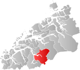
 Norddal within Møre og Romsdal | |
| Coordinates: 62°17′32″N 07°26′18″E / 62.29222°N 7.43833°E | |
| Country | Norway |
| County | Møre og Romsdal |
| District | Sunnmøre |
| Established | 1 Jan 1838 |
| • Created as | Formannskapsdistrikt |
| Disestablished | 1 Jan 2020 |
| • Succeeded by | Fjord Municipality |
| Administrative centre | Sylte |
| Government | |
| • Mayor (2015-2019) | Arne Sandnes (Sp) |
| Area (upon dissolution) | |
| • Total | 943.51 km2 (364.29 sq mi) |
| • Land | 900.46 km2 (347.67 sq mi) |
| • Water | 43.05 km2 (16.62 sq mi) 4.6% |
| • Rank | #116 in Norway |
| Population (2018) | |
| • Total | 1,670 |
| • Rank | #345 in Norway |
| • Density | 1.9/km2 (5/sq mi) |
| • Change (10 years) | |
| Demonym | Norddaling[1] |
| Official language | |
| • Norwegian form | Nynorsk |
| Time zone | UTC+01:00 (CET) |
| • Summer (DST) | UTC+02:00 (CEST) |
| ISO 3166 code | NO-1524[3] |
Norddal is a former municipality in Møre og Romsdal county, Norway. It merged with Stordal municipality to establish the new Fjord municipality in 2020. It covered the easternmost part of the Sunnmøre region along the border with Oppland county. The municipal center of the municipality was the village of Sylte (also known as Valldal) in the Valldalen valley.
Norddal covered an area with several distinct valleys and villages: Eidsdal and Norddal (Dalsbygda) in the south; Tafjord in the east; and Fjørå/Selboskarbygda and Sylte in the Valldalen valley in the north. Norwegian County Road 63 traverses the municipality from south to north, going through several tunnels in the mountains including the Stordal Tunnel. The Heggur Tunnel connects the isolated village of Tafjord with the rest of the municipality.
At the time if its dissolution in 2020, the 944-square-kilometre (364 sq mi) municipality is the 116th largest by area out of the 422 municipalities in Norway. Norddal is the 345th most populous municipality in Norway with a population of 1,670. The municipality's population density is 1.9 inhabitants per square kilometre (4.9/sq mi) and its population has decreased by 5.2% over the last decade.[4][5]
- ^ "Navn på steder og personer: Innbyggjarnamn" (in Norwegian). Språkrådet.
- ^ "Forskrift om målvedtak i kommunar og fylkeskommunar" (in Norwegian). Lovdata.no.
- ^ Bolstad, Erik; Thorsnæs, Geir, eds. (26 January 2023). "Kommunenummer". Store norske leksikon (in Norwegian). Kunnskapsforlaget.
- ^ Statistisk sentralbyrå (2018). "Table: 06913: Population 1 January and population changes during the calendar year (M)" (in Norwegian). Retrieved 24 August 2019.
- ^ Statistisk sentralbyrå. "09280: Area of land and fresh water (km²) (M)" (in Norwegian). Retrieved 24 August 2019.

