Back Priboj BS Прибой (Серби) CE Priboj (Srbsko) Czech Priboj Danish Priboj (Priboj) German Priboj Spanish Priboj Estonian پریبوی Persian Priboj French Priboj Croatian
Priboj
Прибој (Serbian) | |
|---|---|
Town and municipality | |
 Location of the municipality of Priboj within Serbia | |
| Coordinates: 43°36′N 19°32′E / 43.600°N 19.533°E | |
| Country | |
| Region | Šumadija and Western Serbia |
| District | Zlatibor |
| Settlements | 33 |
| Government | |
| • Predsednik | Lazar Rvović (SNS) |
| Area | |
| • Town | 6.07 km2 (2.34 sq mi) |
| • Municipality | 553 km2 (214 sq mi) |
| Elevation | 882 m (2,894 ft) |
| Highest elevation | 1,500 m (4,900 ft) |
| Lowest elevation | 392 m (1,286 ft) |
| Population (2022 census)[2] | |
| • Town | 13,172 |
| • Town density | 2,200/km2 (5,600/sq mi) |
| • Municipality | 23,514 |
| • Municipality density | 43/km2 (110/sq mi) |
| Time zone | UTC+1 (CET) |
| • Summer (DST) | UTC+2 (CEST) |
| Postal code | 31330 |
| Area code | +381(0)33 |
| Car plates | PB |
| Website | www |
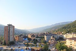
Priboj (Serbian Cyrillic: Прибој, pronounced [prǐːbɔj]) is a town and municipality located in the Zlatibor District of southwestern Serbia. The population of the town is 13,172, while the population of the municipality is 23,514.[3]
- ^ "Municipalities of Serbia, 2006". Statistical Office of Serbia. Retrieved 2010-11-28.
- ^ "2022 Census of Population, Households and Dwellings: Ethnicity (data by municipalities and cities)" (PDF). Statistical Office of Republic Of Serbia, Belgrade. April 2023. ISBN 978-86-6161-228-2. Retrieved 2023-04-30.
- ^ "2022 Census of Population, Households and Dwellings" (PDF). Retrieved 2023-12-07.


