Back Welburn (parokya sa Hiniusang Gingharian, lat 54,10, long -0,89) CEB Welburn (Derwent) LLD Welburn Dutch Welburn (Amotherby) Polish Welburn, Derwent Swedish Welburn, Derwent Turkish
| Welburn | |
|---|---|
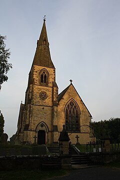
 St John the Evangelist | |
Location within North Yorkshire | |
| Population | 516 (2011 census)[1] |
| OS grid reference | SE720680 |
| Civil parish |
|
| Unitary authority | |
| Ceremonial county | |
| Region | |
| Country | England |
| Sovereign state | United Kingdom |
| Post town | YORK |
| Postcode district | YO60 |
| Dialling code | 01653 |
| Police | North Yorkshire |
| Fire | North Yorkshire |
| Ambulance | Yorkshire |
| UK Parliament | |
Welburn is a village and civil parish in North Yorkshire, England, on the north bank of the River Derwent. It lies on the edge of the Howardian Hills, near to the stately home Castle Howard. It is about 14 miles from York and 5 miles south-west of Malton/Norton. It is a popular area for walkers and bird-watchers. The parish's population was estimated at 523 people in 2013.[2] This figure includes the developments at Crambeck, Holmes Crescent and Chestnut Avenue that are some distance outside the heart of the village.
It is a traditional village in regards to its linear structure. The Main Street has two main offshoots; one lane, to the south, is called Church Lane (formerly Bank Lane) and leads to St John the Evangelist Church, built in 1858,[3] to the newly built Village Hall, and to a small area of housing, mostly constructed in the 1960s. The lane leading northwards is called Water Lane, a short section of road serving two properties and over a small stream to farmland. Main Street continues south-eastwards of the village centre as Chestnut Avenue to join the main A64 road to Malton and York.
Welburn was part of the Ryedale district from 1974 to 2023. It is now administered by the unitary North Yorkshire Council.
It has one school, Welburn Community School, in the centre of the village. It also has a pub, the Crown and Cushion, which provides a centre for the village and Four and Twenty Blackbirds, village bakery and café. Welburn is one of the few villages in the area that still has a red telephone box (located near the centre of the village); they are becoming an increasing rarity in North Yorkshire.
The parish council of the area is based at Welburn Village Hall. It has elected members from Welburn and Crambeck, an adjoining settlement. Crambeck, formerly a reformatory school, was used in the Roman period times as the site of a pottery.[4] The Roman ceramic produced here is known as Crambeck Ware. The recently redeveloped Village Hall, operational since May 2007, is used for a range of activities and groups in the village and the surrounding area. These groups include the Women's Institute, horticultural society, indoor bowling club, country dancing, Local History Group, Wine Club and an Art & Craft club. The eco-friendly Village Hall is a gathering place for villagers and local walkers.[2]
- ^ UK Census (2011). "Local Area Report – Welburn (Amotherby Ward) Parish (E04007646)". Nomis. Office for National Statistics. Retrieved 14 September 2023.
- ^ a b "Welburn Parish Council". www.parishcouncil.welburn.info. Retrieved 30 October 2017.
- ^ 'The Pride of Yorkshire', exhibition leaflet, Castle Howard, 2010
- ^ Corder, P. 1928. The Roman Pottery at Crambeck, Castle Howard (Roman Malton and District Report no.1). York: William Sessions
