Back نهر أخيلوس Arabic نهر اخيلوس ARZ Ахелой (Гърция) Bulgarian Riu Aqueloos Catalan Achelóos Potamós CEB Achelóos (řeka) Czech Ахелоос CV Achelous (flod) Danish Αχελώος Greek Achelous River English
| Acheloos Αχελώος | ||
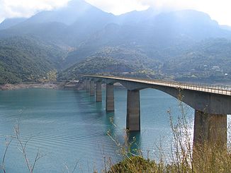
 Episkopi-Brücke | ||
| Daten | ||
| Lage | Epirus, Thessalien, Westgriechenland (Griechenland) | |
| Flusssystem | Acheloos | |
| Quelle | Lakmos 39° 40′ 36″ N, 21° 9′ 56″ O | |
| Quellhöhe | 2000 m | |
| Mündung | Golf von Patras (Ionisches Meer)Koordinaten: 38° 20′ 6″ N, 21° 6′ 15″ O 38° 20′ 6″ N, 21° 6′ 15″ O | |
| Mündungshöhe | 0 m | |
| Höhenunterschied | 2000 m | |
| Sohlgefälle | 9,2 ‰ | |
| Länge | 217 km | |
| Einzugsgebiet | 6329 km² | |
| Rechte Nebenflüsse | Agrafiotis, Karpenisiotis, Trikeriotis, Tavropos | |
| Durchflossene Stauseen | Stratos-Stausee, Sykia-Talsperre, Mesochora-Stausee, Kremasta-Stausee, Kastraki-Stausee | |
 Verlauf des Flusses Acheloos in Griechenland (modifiziertes Satellitenbild aus Nasa World Wind) | ||
 Templa-Steinbrücke (erbaut 1904) | ||
Acheloos (griechisch Αχελώος) ist der Name des wasserreichsten Flusses in Griechenland. Er ist 217 km lang und damit der zweitlängste Fluss in Griechenland nach dem Aliakmonas. Der Acheloos durchfließt die Regionen Epirus, Thessalien und Westgriechenland.