Back Anuta ACE أنوتا Arabic انوتا ARZ Anuta AST Анута Byelorussian Анута Bulgarian Anuta CEB Anuta English Anuta Spanish Anuta Estonian
| Anuta Island (Cherry Island) | ||
|---|---|---|
 | ||
| Gewässer | Pazifischer Ozean | |
| Inselgruppe | Santa-Cruz-Inseln | |
| Geographische Lage | 11° 36′ 39″ S, 169° 51′ 1″ O | |
|
| ||
| Länge | 876 m | |
| Breite | 576 m | |
| Fläche | 37 ha | |
| Höchste Erhebung | Te Maunga 65 m | |
| Einwohner | 223 (2009) 603 Einw./km² | |
| Hauptort | Lotoapi (Ortsteil Mua) | |
 | ||
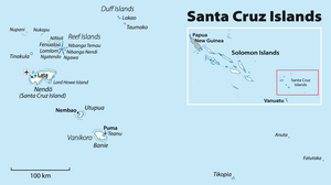
Anuta, auch Anuda, früher Cherry Island, ist eine kleine Insel im südöstlichen Teil der Santa-Cruz-Inseln, die zum Inselstaat Salomonen gehören. Für Europa entdeckt wurde Anuta von dem britischen Kapitän Edward Edwards, den die Admiralität ausgesandt hatte, um nach den Meuterern der Bounty zu suchen. Er erreichte am 12. August 1791 mit seiner Fregatte Pandora die Insel, ohne dort an Land zu gehen, und nannte sie Cherry.[1]
- ↑ John Dunmore: Who's who in Pacific navigation. University of Hawaii Press, Honolulu HI 1991, ISBN 0-8248-1350-2, S. 95–96.
