Back Buldır adası Azerbaijani Illa Buldir Catalan Buldir Island CEB Buldir Island English Île Buldir French Buldir Italian バルディア島 Japanese Buldir Dutch Ilha Buldir Portuguese Булдырь Russian
| Buldir Island | ||
|---|---|---|
 | ||
| Gewässer | Pazifischer Ozean | |
| Inselgruppe | Aleuten | |
| Geographische Lage | 52° 21′ 0″ N, 175° 56′ 0″ O | |
|
| ||
| Länge | 7 km | |
| Breite | 4 km | |
| Fläche | 19,291 km² | |
| Höchste Erhebung | Buldir-Vulkan 656 m | |
| Einwohner | unbewohnt | |
 | ||
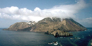
Buldir Island (auch Buldyr Island) ist eine kleine Insel in den westlichen Aleuten im US-Bundesstaat Alaska. Sie liegt in der Mitte zwischen den Near Islands im Westen und den Rat Islands im Osten.
