Back Mbarara District CEB Mbarara district English Distrito de Mbarara Spanish Mbarara (district) French Distrik Mbarara ID Distretto di Mbarara Italian ムバララ県 Japanese 음바라라구 Korean Mbarara (disitulikit) LG Mbarara (district) Dutch
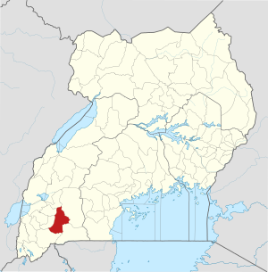
| Karte | |
|---|---|
 Lage von Mbarara | |
| Basisdaten | |
| Hauptstadt | Mbarara |
| Geographisches Zentrum | 0° 36′ S, 30° 36′ O |
| Fläche | 1.846,4 km² |
| Einwohnerzahl | 390.700 (Stand 2020) |
| Bevölkerungsdichte | 211,6 Einwohner/km² |
| Zeitzone | UTC +3 |
| ISO 3166-2 | UG-410 |
Mbarara ist ein Distrikt (district) in West-Uganda mit 390.700 Einwohnern. Wie fast alle Distrikte von Uganda ist er nach seinem Hauptort – Mbarara – benannt. Mbarara liegt im Südwesten Ugandas an der Grenze zu Tansania.