Back Lennox and Addington County CEB Lennox and Addington County English شهرستان لنکس و ادینگتون Persian Comté de Lennox et Addington French Contea di Lennox e Addington Italian レノックス・アディントン郡 Japanese Hrabstwo Lennox and Addington Polish لینکس تے ایڈنگٹن کاؤنٹی PNB Condado de Lennox e Addington Portuguese Kontea Lennox e Addington Albanian
| Lennox and Addington County | |
|---|---|
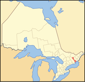
 Lage der Region in Ontario
| |
| Basisdaten | |
| Staat | Kanada |
| Provinz | Ontario
|
| Verwaltungssitz | Greater Napanee |
| Koordinaten: | 44° 39′ N, 77° 9′ W |
| Einwohner | 42.888 (Stand: 2016[1]) |
| Fläche | 2.839,68 km² |
| Bevölkerungsdichte | 15,1 Einw./km² |
| Zeitzone: | Eastern Standard Time (UTC−5) Eastern Daylight Time (UTC−4, Sommerzeit) |
| Webpräsenz | www.lennox-addington.on.ca |
Lennox and Addington County ist ein County im Südosten der kanadischen Provinz Ontario. Der County Seat ist Greater Napanee. Die Einwohnerzahl beträgt 42.888 (Stand: 2016), die Fläche 2839,68 km², was einer Bevölkerungsdichte von 15,1 Einwohnern je km² entspricht. Das County liegt am Nordufer des Ontariosees und entstand 1850 durch die Fusion der Countys Lennox und Addington, die nach Charles Lennox, 3. Duke of Richmond bzw. Henry Addington, 1. Viscount Sidmouth, benannt waren.
Im Bezirk liegen mehrere der Provincial Parks in Ontario. Im Nordosten unter anderem der bezirksübergreifende Bon Echo Provincial Park, der mit den Mazinaw Pictographs eine der National Historic Site of Canada beherbergt.
| Renfrew County | ||
| Hastings County | 
|
Frontenac County |
| Prince Edward County | Ontariosee |