Back ليندسفارن Arabic لیندیسفارن AZB Линдисфарн Bulgarian Lindisfarne Breton Lindisfarne Catalan Holy Island (pulo sa Hiniusang Gingharian, Inglatera, lat 55,68, long -1,80) CEB Lindisfarne Czech Lindisfarne Welsh Lindisfarne Danish Λίντισφαρν Greek
| Lindisfarne | ||
|---|---|---|
 | ||
| Gewässer | Nordsee | |
| Geographische Lage | 55° 40′ 41″ N, 1° 47′ 44″ W | |
|
| ||
| Fläche | 4 km² | |
| Einwohner | ca. 160 (2013) 40 Einw./km² | |
| Hauptort | Holy Island Village | |
 | ||

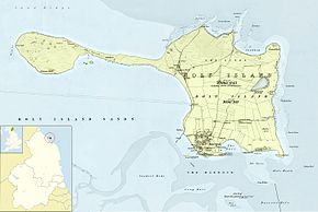
Lindisfarne, auch Holy Island genannt, ist eine Gezeiteninsel an der Nordostküste Northumberlands in England. Ein großer Teil der Insel sowie die Gezeitenzone sind Vogelschutzgebiet. Hier können bis zu 300 Vogelarten, sowohl Zugvögel als auch einheimische Vögel, beobachtet werden. Lindisfarne ist durch eine nur bei Niedrigwasser befahrbare Straße mit dem Festland verbunden.
Am 27. März 2011 wurden 180 Einwohner gezählt.[1] Viele Häuser werden nur als Sommerhäuser genutzt, und es fehlt bezahlbarer Wohnraum besonders für junge Leute.[2]
- ↑ Holy Island Ward population 2011 ( des vom 3. Juli 2016 im Internet Archive) Info: Der Archivlink wurde automatisch eingesetzt und noch nicht geprüft. Bitte prüfe Original- und Archivlink gemäß Anleitung und entferne dann diesen Hinweis.
- ↑ Mark Rowe, Fatal attraction: the residents of Lindisfarne in Northumberland are facing a Catch 22: although the future of the Holy Island depends on the development of tourism, many fear that it will end up destroying its distinctive character. Geographical 86/5, 2014.
