Back مقاطعة مونتغومري (ماريلاند) Arabic Montqomeri qraflığı (Merilend) Azerbaijani Montgomery County, Maryland BAR Монтгомъри (окръг, Мериленд) Bulgarian মন্টগোমেরী কাউন্টি, মেরিল্যান্ড BPY Comtat de Montgomery (Maryland) Catalan Montgomery Gông (Maryland) CDO Монтгомери (гуо, Мэриленд) CE Montgomery County (kondado sa Tinipong Bansa, Maryland) CEB Montgomery County, Maryland Welsh
 | |
| Verwaltung | |
|---|---|
| US-Bundesstaat: | Maryland |
| Verwaltungssitz: | Rockville |
| Adresse des Verwaltungssitzes: |
Executive Office Building 101 Monroe Street Rockville, MD 20850 |
| Gründung: | 1776 |
| Gebildet aus: | Frederick County, Prince George’s County, Charles County |
| Vorwahl: | 001 240 |
| Demographie | |
| Einwohner: | 1.062.061 (Stand: 2020) |
| Bevölkerungsdichte: | 827,8 Einwohner/km2 |
| Geographie | |
| Fläche gesamt: | 1313 km² |
| Wasserfläche: | 30 km² |
| Karte | |
 | |
| Website: www.montgomerycountymd.gov | |
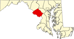
Das Montgomery County[2] ist ein County im US-Bundesstaat Maryland.
Der Verwaltungssitz (County Seat) ist Rockville. Bei der Volkszählung im Jahr 2020 hatte das County 1.062.061 Einwohner und eine Bevölkerungsdichte von 828 Einwohnern pro Quadratkilometer.[3]
Das Montgomery County ist Bestandteil der Metropolregion um die US-Hauptstadt Washington, D.C.
- ↑ Auszug aus dem National Register of Historic Places - Nr. 86003352 Abgerufen am 4. September 2011
- ↑ Montgomery County (Maryland). In: Geographic Names Information System. United States Geological Survey, United States Department of the Interior, abgerufen am 5. September 2024 (englisch).
- ↑ Maryland (Bundesstaat, USA) - Einwohnerzahlen, Grafiken, Karte und Lage. Abgerufen am 1. März 2022.