Back N1 (Suid-Afrika) Afrikaans N1 (South Africa) English N1 (Sudáfrica) Spanish Route nationale 1 (Afrique du Sud) French National Route 1 (Sudafrica) Italian N1 (Zuid-Afrika) Dutch N1 (Sør-Afrika) NB Автошлях N1 (ПАР) Ukrainian 1號國道 (南非) Chinese N1 Zulu
| National Route N1 in Südafrika | |||||||||||||||||||||||||||||||||||||||||||||||||||||||||||||||||||||||||||||||||||||||||||||||||||||||||||||||||||||||||

| |||||||||||||||||||||||||||||||||||||||||||||||||||||||||||||||||||||||||||||||||||||||||||||||||||||||||||||||||||||||||
| | |||||||||||||||||||||||||||||||||||||||||||||||||||||||||||||||||||||||||||||||||||||||||||||||||||||||||||||||||||||||||
| Karte | |||||||||||||||||||||||||||||||||||||||||||||||||||||||||||||||||||||||||||||||||||||||||||||||||||||||||||||||||||||||||

| |||||||||||||||||||||||||||||||||||||||||||||||||||||||||||||||||||||||||||||||||||||||||||||||||||||||||||||||||||||||||
| Basisdaten | |||||||||||||||||||||||||||||||||||||||||||||||||||||||||||||||||||||||||||||||||||||||||||||||||||||||||||||||||||||||||
| Betreiber: | South African National Roads Agency | ||||||||||||||||||||||||||||||||||||||||||||||||||||||||||||||||||||||||||||||||||||||||||||||||||||||||||||||||||||||||
| Straßenbeginn: | Kapstadt (33° 54′ 52″ S, 18° 25′ 26″ O) | ||||||||||||||||||||||||||||||||||||||||||||||||||||||||||||||||||||||||||||||||||||||||||||||||||||||||||||||||||||||||
| Straßenende: | Musina (22° 13′ 27″ S, 29° 59′ 12″ O) | ||||||||||||||||||||||||||||||||||||||||||||||||||||||||||||||||||||||||||||||||||||||||||||||||||||||||||||||||||||||||
| Gesamtlänge: | 1940 km | ||||||||||||||||||||||||||||||||||||||||||||||||||||||||||||||||||||||||||||||||||||||||||||||||||||||||||||||||||||||||
 | |||||||||||||||||||||||||||||||||||||||||||||||||||||||||||||||||||||||||||||||||||||||||||||||||||||||||||||||||||||||||
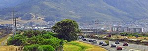
| Die N1 bei Century City, einem Vorort Kapstadts | |||||||||||||||||||||||||||||||||||||||||||||||||||||||||||||||||||||||||||||||||||||||||||||||||||||||||||||||||||||||||
Straßenverlauf
| |||||||||||||||||||||||||||||||||||||||||||||||||||||||||||||||||||||||||||||||||||||||||||||||||||||||||||||||||||||||||
Die National Route 1 (kurz N1) ist eine südafrikanische Nationalstraße, die von Kapstadt zur Grenze nach Simbabwe nördlich der Kleinstadt Musina führt. Sie ist auch die Hauptverbindung zwischen Johannesburg und Kapstadt. Ihr südwestlicher Abschnitt bis zur N12 ist zugleich eine Strecke des Trans-African-Highway Kairo-Gaborone-Kapstadt.