Back نهر نيث ARZ River Nith CEB Nith Czech Нит (юханшыв, Шотланди) CV Afon Nith Welsh River Nith English Río Nith Spanish Nith ibaia Basque Nith (Écosse) French Nith Frisian
| Nith | ||
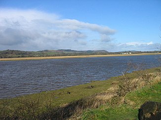
 Der Nith ein kurzes Stück vor der Mündung | ||
| Daten | ||
| Lage | East Ayrshire, Dumfries and Galloway, Schottland | |
| Flusssystem | Nith | |
| Abfluss über | Solway Firth → Irische See | |
| Flussgebietseinheit | Solway Tweed XRBD | |
| Quelle | An den Hängen des Enoch Hill 55° 19′ 40″ N, 4° 17′ 8″ W | |
| Quellhöhe | 425 m ASL[1] | |
| Mündung | Südlich von Dumfries in den Solway FirthKoordinaten: 54° 56′ 59″ N, 3° 32′ 7″ W 54° 56′ 59″ N, 3° 32′ 7″ W
| |
| Länge | 112 km[2] | |
| Linke Nebenflüsse | Cample Water, Mennock Water, Crawick Water | |
| Rechte Nebenflüsse | Cluden Water, Kello Water, Afton Water, Euchan Water, Scaur Water | |
Der Nith ist ein Fluss in den schottischen Council Areas East Ayrshire und Dumfries and Galloway beziehungsweise den historischen Grafschaften Ayrshire, Kirkcudbrightshire und Dumfriesshire.[1][2] Er ist namensgebend für die historische Provinz Nithsdale.
- ↑ a b Nith in: F. H. Groome: Ordnance Gazetteer of Scotland: A Survey of Scottish Topography, Statistical, Biographical and Historical. Grange Publishing, Edinburgh, 1885.
- ↑ a b Eintrag im Gazetteer for Scotland