Back شمال بحر الغزال (ولاية) Arabic Северен Бахър ал Газал Bulgarian Bahr al-Ghazal del nord Catalan Northern Bahr el Ghazal (estado sa Habagatang Sudan) CEB Northern Bahr el Ghazal English Norda Bahr el Ghazal Esperanto Estado de Bar el Gazal del Norte Spanish Pohjoinen Bahr el-Ghazal Finnish Bahr el Ghazal du Nord French צפון בחר אל-ע'זאל HE
| Northern Bahr el Ghazal | ||
|---|---|---|
 | ||
| Symbole | ||
| ||
| Basisdaten | ||
| Staat | Südsudan | |
| Hauptstadt | Aweil | |
| Fläche | 33.558 km² | |
| Einwohner | 720.898 (Zensus 2008) | |
| Dichte | 21 Einwohner pro km² | |
| ISO 3166-2 | SS-BN | |
| Politik | ||
| Gouverneur | Uber Ajonga Mawut (SPLM)[1] | |

Koordinaten: 8° 46′ N, 27° 24′ O
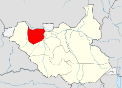
Northern Bahr el Ghazal (arabisch شمال بحر الغزال Schamāl Bahr al-Ghazāl, DMG Šamāl Baḥr al-ġazāl ‚Nördlicher Gazellen-Fluss‘) ist ein Bundesstaat im Südsudan.
Er hat eine Fläche von 33.558 km²[2] und gemäß dem Zensus von 2008 rund 720.000 Einwohner[3]. Seine Hauptstadt ist Aweil, weitere größere Orte sind Malual Kon, Marial Bai, Wed Weil und Nyamlell.
- ↑ Sudans Post: Kiir replaces Northern Bahr el Ghazal governor with brother of ex-army chief. In: Sudans Post. 24. Juni 2024, abgerufen am 26. Juni 2024 (amerikanisches Englisch).
- ↑ Key Indicators for Northern Bahr el Ghazal. Abgerufen am 31. März 2019.
- ↑ Central Bureau of Statistics/Southern Sudan Centre for Census Statistics and Evaluation: 5th Sudan Population and Housing Census – 2008 ( des vom 20. Mai 2013 im Internet Archive) Info: Der Archivlink wurde automatisch eingesetzt und noch nicht geprüft. Bitte prüfe Original- und Archivlink gemäß Anleitung und entferne dann diesen Hinweis. (PDF; 425 kB), Table: T02