Back Parry Sound District CEB Parry Sound District English بخش پری ساوند Persian District de Parry Sound French Distretto di Parry Sound Italian パリーサウンド地区 Japanese Dystrykt Parry Sound Polish ضلع پیری ساؤنڈ PNB Parry Sound (distrito) Portuguese Парри-Саунд (округ) Russian
| Parry Sound District | |
|---|---|
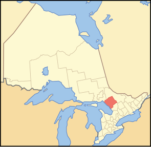
 Lage der Region in Ontario
| |
| Basisdaten | |
| Staat | Kanada |
| Provinz | Ontario
|
| Verwaltungssitz | Parry Sound |
| Koordinaten: | 45° 43′ N, 79° 48′ W |
| Einwohner | 42.824 (Stand: 2016[1]) |
| Fläche | 9.326,48 km² |
| Bevölkerungsdichte | 4,6 Einw./km² |
| Zeitzone: | Eastern Standard Time (UTC−5) Eastern Daylight Time (UTC−4, Sommerzeit) |
Der Parry Sound District ist ein Verwaltungsbezirk im Zentrum der kanadischen Provinz Ontario. Hauptort ist Parry Sound. Die Einwohnerzahl beträgt 42.824 (Stand: 2016), die Fläche 9326,48 km², was einer Bevölkerungsdichte von 4,6 Einwohnern je km² entspricht. Der Bezirk liegt am Ostufer der Georgsbucht des Huronsees und umfasst einen Teil des Biosphärenreservat Frontenac Arch.
| Sudbury District | Nipissing District | |
| Georgian Bay (Huronsee) | 
|
Nipissing District |
| Muskoka District Municipality |
- ↑ Statistics Canada: Census Profile, 2016 Census – Parry Sound, District (Census division), Ontario and Ontario (Province), abgerufen am 27. Mai 2021