Back توماستون، مئین AZB Томастон (Мэн) CE Thomaston, Maine Welsh Thomaston, Maine English Thomaston (Maine) Spanish Thomaston (Maine) Basque توماستون (مین) Persian Thomaston (Maine) French Thomaston, Maine HT Thomaston (Maine) Italian
| Thomaston | ||
|---|---|---|
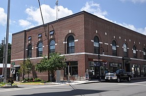
 Thomaston Town Hall (Rathaus) | ||
| Lage in Maine | ||
|
| ||
| Basisdaten | ||
| Gründung: | 20. März 1777 | |
| Staat: | Vereinigte Staaten | |
| Bundesstaat: | Maine | |
| County: | Knox County | |
| Koordinaten: | 44° 6′ N, 69° 10′ W | |
| Zeitzone: | Eastern (UTC−5/−4) | |
| Einwohner: | 2.739 (Stand: 2020) | |
| Haushalte: | 1.417 (Stand: 2020) | |
| Fläche: | 29,73 km² (ca. 11 mi²) davon 28,33 km² (ca. 11 mi²) Land | |
| Bevölkerungsdichte: | 97 Einwohner je km² | |
| Höhe: | 28 m | |
| Postleitzahl: | 04861 | |
| Vorwahl: | +1 207 | |
| FIPS: | 23-76365 | |
| GNIS-ID: | 0582763 | |
| Website: | www.town.thomaston.me.us/public/ | |
 Montpelier, Henry Knox Home | ||
Thomaston[1] ist eine Town im Knox County des Bundesstaates Maine in den Vereinigten Staaten. Im Jahr 2020 lebten dort 2739 Einwohner in 1407 Haushalten[2] auf einer Fläche von 29,73 km².[3]
- ↑ Thomaston. In: Geographic Names Information System. United States Geological Survey, United States Department of the Interior (englisch)., abgerufen am 30. September 2018
- ↑ Explore Census Data. In: census.gov. data.census.gov, abgerufen am 10. Oktober 2021.
- ↑ Volkszählungsergebnisse Maine 2010; offizielle Publikation der Census-Behörde, (englisch; PDF; 32,5 MB)
