Back 2023年の台風 Japanese 2023년 태풍 Korean Temporada de tufões no Pacífico de 2023 Portuguese ฤดูพายุไต้ฝุ่นแปซิฟิก พ.ศ. 2566 Thai Panahon ng bagyo sa Pasipiko ng 2023 Tagalog Mùa bão Tây Bắc Thái Bình Dương 2023 Vietnamese 2023年太平洋颱風季 Chinese
| 2023 Pacific typhoon season | |
|---|---|
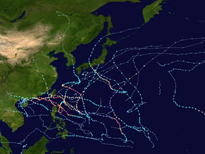
 Season summary map | |
| Seasonal boundaries | |
| First system formed | March 4, 2023 |
| Last system dissipated | December 18, 2023 |
| Strongest storm | |
| Name | Mawar |
| • Maximum winds | 215 km/h (130 mph) (10-minute sustained) |
| • Lowest pressure | 900 hPa (mbar) |
| Seasonal statistics | |
| Total depressions | 29 |
| Total storms | 17 |
| Typhoons | 10 |
| Super typhoons | 4 (unofficial)[nb 1] |
| Total fatalities | 191 total |
| Total damage | $37.5 billion (2023 USD) (Second-costliest Pacific typhoon season on record) |
| Related articles | |
The 2023 Pacific typhoon season was the fourth and final consecutive below-average season and became the third-least active typhoon season on record in terms of named storms, with just 17 named storms developing, only ahead of 2010 and 1998. Despite the season occurring during an El Niño event, which typically favors activity in the basin, activity was abnormally low. This was primarily due to a consistent period of negative PDO, which typically discourages tropical storm formation in this basin.[1] The season was less active than the 2023 Atlantic hurricane season in terms of named storms, the fourth such season on record, after 2005, 2010 and 2020. The season's number of storms also did not exceed that of the 2023 Pacific hurricane season. Only ten became typhoons, with four strengthening further into super typhoons. However, it was very destructive, primarily due to Typhoon Doksuri which devastated the northern Philippines, Taiwan, and China in July, becoming the costliest typhoon on record as well as the costliest typhoon to hit mainland China, and Typhoon Haikui in September, which devastated China, Taiwan, and Hong Kong. The season was less active in Southeast Asia, with no tropical storm making landfall in mainland Vietnam (the third since the country's independence, after the 1976 and 2002 seasons).[2][3]
The season ran throughout 2023, though most tropical cyclones typically develop between May and October. The season's first named storm, Sanvu, formed on April 21, while its last named storm, Jelawat, dissipated on December 20. In May, Typhoon Mawar intensified into the first typhoon of the season on May 21, later becoming one of the strongest Northern Hemisphere tropical cyclones on record in May.[4]
The scope of this article is limited to the Pacific Ocean to the north of the equator between 100°E and 180th meridian. Within the northwestern Pacific Ocean, there are two agencies which assign names to tropical cyclones which can often result in a cyclone having two names. The Japan Meteorological Agency (JMA)[nb 2] will name a tropical cyclone if it has 10-minute sustained wind speeds of at least 65 km/h (40 mph) anywhere in the basin, while the Philippine Atmospheric, Geophysical and Astronomical Services Administration (PAGASA) assigns names to tropical cyclones which are active in the Philippine Area of Responsibility (PAR), located between 135°E and 115°E and between 5°N–25°N, regardless of whether or not a tropical cyclone has already been given a name by the JMA. Tropical depressions that are monitored by the United States' Joint Typhoon Warning Center (JTWC)[nb 3][nb 1] are given a number with a "W" suffix.
Cite error: There are <ref group=nb> tags on this page, but the references will not show without a {{reflist|group=nb}} template (see the help page).
- ^ "Pacific Decadal Oscillation (PDO) | National Centers for Environmental Information (NCEI)". www.ncei.noaa.gov. Retrieved March 4, 2024.
- ^ "Thời tiết ngày càng dị thường". December 30, 2023.
- ^ "Thời tiết năm 2023 phá vỡ nhiều quy luật". December 30, 2023.
- ^ Masters, Jeff (May 25, 2023). "Category 5 Super Typhoon Mawar rapidly intensifies to 175 mph winds". New Haven, Connecticut: Yale Climate Connections. Archived from the original on May 27, 2023. Retrieved May 27, 2023.
- ^ "Joint Typhoon Warning Center Mission Statement". Joint Typhoon Warning Center. 2011. Archived from the original on July 26, 2007. Retrieved July 25, 2012.
- ^ Frequently Asked Questions (Report). Joint Typhoon Warning Center. August 13, 2012. Archived from the original on October 4, 2013. Retrieved September 22, 2012.