This article relies largely or entirely on a single source. (October 2024) |
| A6079 | ||||
|---|---|---|---|---|
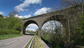
 A6079 road looking north at a bridge of the Border Counties Railway near Chollerton | ||||
| Route information | ||||
| Length | 8 mi (13 km) | |||
| Major junctions | ||||
| North end | A68 | |||
| South end | Hexham | |||
| Location | ||||
| Country | United Kingdom | |||
| Road network | ||||
| ||||
The A6079 is a road in Northumberland, northern England, that runs eight miles (13 km) from Hexham to the A68 road.[citation needed]

