Back Adachi, Tokyo ACE أداتشي (طوكيو) Arabic Adaçi Azerbaijani Adachi (Tòquio) Catalan Адати CE Adachi-ku CEB ئاداچی، تۆکیۆ CKB Adachi Danish Adachi German Kvartalo Adaĉi Esperanto
Adachi
足立区 | |
|---|---|
| Adachi City | |
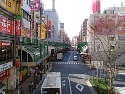
 A street in front of Kita-Senju Station in Adachi | |
 Location of Adachi in Tokyo Metropolis | |
| Coordinates: 35°47′N 139°48′E / 35.783°N 139.800°E | |
| Country | Japan |
| Region | Kantō |
| Prefecture | Tokyo Metropolis |
| First official recorded | 826 AD |
| As merged with Tokyo City | October 1, 1932 |
| As special ward became to Tokyo | July 1, 1943 |
| Government | |
| • Mayor | Yayoi Kondo (since June 2007) |
| Area | |
| • Total | 53.25 km2 (20.56 sq mi) |
| Population (October 1, 2020[1]) | |
| • Total | 695,043 |
| • Density | 13,052/km2 (33,800/sq mi) |
| Time zone | UTC+09:00 (JST) |
| City hall address | Chūōhonchō 1-17-1, Adachi-ku, Tokyo 120-8510 |
| Website | www |
| Symbols | |
| Flower | Tulip |
| Tree | Cherry Blossom |


Adachi (足立区, Adachi-ku) is a special ward in the Tokyo Metropolis in Japan. It is located to the north of the heart of Tokyo. The ward consists of two separate areas: a small strip of land between the Sumida River and Arakawa River and a larger area north of the Arakawa River. The ward is bordered by the cities of Kawaguchi, Sōka and Yashio in Saitama and Katsushika, Sumida, Arakawa and Kita in Tokyo. The ward is called Adachi City in English.
As of May 1, 2015, the ward has an estimated population of 692,707 and a population density of 13,010 persons per km2. The total area is 53.25 km2.
The Adachi Land Transportation Office is located here, and automobiles registered at this office bear Adachi number plates.
- ^ "Population by District". Tokyo Statistical Yearbook. Retrieved July 15, 2022.


