Back أدميرالتي (جزيرة) Arabic Admiralti adası Azerbaijani Адмиралти (остров, Аляска) Bulgarian Admiralty Catalan Admiralty Island (pulo sa Tinipong Bansa) CEB Admiralty Island German Άντμιραλτι (νησί) Greek Isla del Almirantazgo Spanish Admiralty saar Estonian Almirantegoaren uhartea Basque
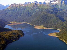
 Colt Island and Horse Island with Admiralty Island in the background | |
 | |
| Geography | |
|---|---|
| Location | ABC islands of Alaska |
| Coordinates | 57°44′N 134°20′W / 57.733°N 134.333°W |
| Archipelago | Alexander Archipelago |
| Area | 1,646.4 sq mi (4,264 km2) |
| Length | 90 mi (140 km) |
| Width | 35 mi (56 km) |
| Highest elevation | 4,800 ft (1460 m) |
| Administration | |
United States | |
| State | Alaska |
| Borough | Hoonah-Angoon Census Area and Juneau |
| Demographics | |
| Population | 650 (2000) |
| Pop. density | 0.39/sq mi (0.151/km2) |
| Admiralty Island National Monument | |
|---|---|
 Windfall Harbor | |
| Location | Alaska, United States |
| Nearest city | Juneau, AK |
| Coordinates | 57°37′05″N 134°09′40″W / 57.61806°N 134.16111°W[1] |
| Area | 955,747 acres (3,867.77 km2) |
| Governing body | U.S. Forest Service |
| Website | www.fs.usda.gov/recarea/tongass/recarea/?recid=78614 |
| Designated | 1978 |
Admiralty Island is an island in the Alexander Archipelago in Southeast Alaska, at 57°44′N 134°20′W / 57.733°N 134.333°W. It is 145 km (90 mi) long and 56 km (35 mi) wide with an area of 4,264.1 km2 (1,646.4 sq mi), making it the seventh-largest island in the United States and the 132nd largest island in the world. It is one of the ABC islands in Alaska. The island is nearly cut in two by the Seymour Canal; to its east is the long, narrow Glass Peninsula. Most of Admiralty Island—955,747 acres (3,868 km2)—is protected as the Admiralty Island National Monument administered by the Tongass National Forest. The Kootznoowoo Wilderness encompasses vast stands of old-growth temperate rainforest. These forests provide some of the best habitat available to species such as brown bears, bald eagles, and Sitka black-tailed deer.
Angoon, a traditional Tlingit community home to 572 people, is the only settlement on the island, although an unpopulated section of the city of Juneau comprises 264.68 km2 (102.19 sq mi) (6.2 percent) of the island's land area near its northern end. The island's total population at the 2000 census was 650.
The national monument is considered sacred space to the Angoon Tribe of Tlingit people, who live on tribal land in the community of Angoon on the western coast of the island. The Tlingits fought to make protection for the island a part of ANILCA legislation, and continue to engage in stewardship of the island's natural resources. Most of Angoon's residents make daily subsistence use of the national monument.[2]
- ^ "Admiralty Island National Monument". Geographic Names Information System. United States Geological Survey, United States Department of the Interior. Retrieved November 18, 2013.
- ^ Admiralty Island National Monument/Kootznoowoo Wilderness, USDA Forest Service, MB-R10-190. (1992)
