Back Almondsbury (kapital sa distrito) CEB Almondsbury Spanish Almondsbury French Almondsbury Italian Almondsbury Dutch Almondsbury Polish Almondsbury Swedish Almondsbury Turkish
| Almondsbury | |
|---|---|
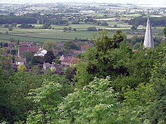
 Part of Almondsbury from The Tump. The spire is Saint Mary the Virgin church. | |
Location within Gloucestershire | |
| Population | 4,705 (2011 census)[1] |
| OS grid reference | ST604843 |
| Civil parish |
|
| Unitary authority | |
| Ceremonial county | |
| Region | |
| Country | England |
| Sovereign state | United Kingdom |
| Post town | BRISTOL |
| Postcode district | BS32 |
| Dialling code | 01454 |
| Police | Avon and Somerset |
| Fire | Avon |
| Ambulance | South Western |
| UK Parliament | |
Almondsbury (English: /ˈɑːməndzbərɪ/) is a large village and civil parish in South Gloucestershire, England. It is situated on the A38 road in the Avon Green Belt 7 miles (11 km) north of Bristol city centre. It is adjacent to junction 16 of the M5 motorway and Almondsbury Interchange, where the M4 and M5 cross. It is part of the Bristol Built-up Area.
The civil parish also includes the villages of Hortham, Gaunt's Earthcott, Over, Easter Compton, Compton Greenfield, Hallen and Berwick.
The village is split by a steep hill, part of the escarpment overlooking the Severn floodplain. At the bottom of the hill is Lower Almondsbury where a pub and hotel, The Bowl Inn, is situated. South Wales, the Forest of Dean, the River Severn and both Severn Bridges are visible from the higher parts of the village, which consists mainly of ribbon development along the A38 and has more of an urban characteristic.[citation needed]
- ^ "Parish population 2011". Archived from the original on 2 April 2015. Retrieved 18 March 2015.
