Back ألتا فيورد Arabic Fiord d'Alta Catalan Altafjorden CEB Altafjord Danish Altafjord German Fiordo de Alta Spanish Altafjorden Estonian Alattionvuono Finnish Altafjord French Ալտա-ֆյորդ Armenian
| |
|---|---|
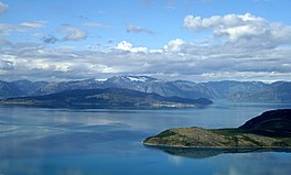
 View of the fjord | |
| Location | Finnmark county, Norway |
| Coordinates | 69°59′24″N 23°19′27″E / 69.9900°N 23.3242°E |
| Type | Fjord |
| Basin countries | Norway |
| Max. length | 38 kilometres (24 mi) |
| Islands | Årøya |
| Settlements | Alta |
The Altafjord (Norwegian: Altafjorden; Northern Sami: Álttávuonna; Kven: Alattionvuono[1]) is a fjord in Alta Municipality in Finnmark county, Norway. The 38-kilometre (24 mi) long fjord stretches from the town of Alta in the south to the islands of Stjernøya and Seiland. The 200-kilometre (120 mi) long river Altaelva empties into the fjord at the town of Alta. At Stjernøya and Seiland islands, the fjord splits into two straits before emptying into the Norwegian Sea. Some of the larger side-branches off the main fjord include Langfjorden, Kåfjorden, and Korsfjorden.[2][3]
The fjord was historically known as "Altenfjord", and was referred to as such by British historians throughout most of the 20th century.

- ^ "Altafjorden". Informasjon om stadnamn (in Norwegian). Kartverket.
- ^ Henriksen, Petter, ed. (2007). "Altafjorden". Store norske leksikon (in Norwegian). Oslo: Kunnskapsforlaget. Retrieved 4 August 2009.
- ^ Henriksen, Petter, ed. (2007). "Altaelva". Store norske leksikon (in Norwegian). Oslo: Kunnskapsforlaget. Retrieved 4 August 2009.

