Back جبل اوبا ايسلاند ARZ Ambae AST Амбае Bulgarian Ambae Aelan Bislama Aoba (pulo sa Wanatu) CEB Ambae German Άμπαε Greek Ambae Esperanto Ambae Spanish Aoba Estonian
This article needs additional citations for verification. (February 2011) |
Aoba | |
|---|---|
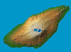
 False color (elevation) and computed shadow map of Ambae
Location within Vanuatu | |
 Map of Ambae | |
| Geography | |
| Location | Pacific Ocean |
| Coordinates | 15°24′0″S 167°50′0″E / 15.40000°S 167.83333°E |
| Archipelago | New Hebrides |
| Area | 398 km2 (154 sq mi) |
| Highest elevation | 1,496 m (4908 ft) |
| Highest point | Aobahi |
| Administration | |
Vanuatu | |
| Province | Penama |
| Demographics | |
| Population | 0 (2018) |
| Ethnic groups | Ni-Vanuatu |
| Aobahi | |
|---|---|
 | |
| Geography | |
| Location | Vanuatu |
| Topo map | 400 km2 (154 sq mi) |
| Geology | |
| Mountain type | Shield volcano |
| Last eruption | June to July 2011[1] |
Ambae, also known as Aoba, Omba, Oba, or Opa and formerly Lepers’ Island, is an island in the South Pacific island nation of Vanuatu, located near 15°30′S 167°30′E / 15.500°S 167.500°E, approximately 310 kilometres (165 nautical miles) north-northwest of Vanuatu's capital city, Port Vila. It is also Vanuatu's largest active volcano.[2]
- ^ "Aoba". Global Volcanism Program. Smithsonian Institution.
- ^ Cronin, Shane J.; Gaylord, David R.; Charley, Douglas; Alloway, Brent V.; Wallez, Sandrine; Esau, Job W. (2004-10-01). "Participatory methods of incorporating scientific with traditional knowledge for volcanic hazard management on Ambae Island, Vanuatu". Bulletin of Volcanology. 66 (7): 652–668. Bibcode:2004BVol...66..652C. doi:10.1007/s00445-004-0347-9. ISSN 1432-0819. S2CID 13613641.