Back Ceinture volcanique d'Anahim French Cintura vulcanica di Anahim Italian Anahim Volcanic Belt LLD Anahim Volcanic Belt SIMPLE
Anahim Volcanic Belt | |
|---|---|
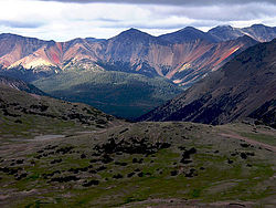
 The Rainbow Range in the central Anahim Volcanic Belt | |
| Coordinates: 52°40′N 125°50′W / 52.667°N 125.833°W | |
| Location | British Columbia, Canada |
| Age | Neogene-to-Quaternary |
| Dimensions | |
| • Length | 330 km (210 mi) |
| Highest elevation | 2,495 m (8,186 ft) |
| Last eruption | 7,200 years ago |
The Anahim Volcanic Belt (AVB) is a west–east trending chain of volcanoes and related magmatic features in British Columbia, Canada. It extends from Athlone Island on the Central Coast, running eastward through the strongly uplifted and deeply dissected Coast Mountains to near the community of Nazko on the Interior Plateau. The AVB is delineated as three west-to-east segments that differ in age and structure. A wide variety of igneous rocks with differing compositions occur throughout these segments, comprising landforms such as volcanic cones, volcanic plugs, lava domes, shield volcanoes and intrusions.
Volcanic activity has occurred repeatedly in the AVB for the last 15 million years, during which time three major magmatic episodes took place 15–13, 9–6 and 3–1 million years ago. These major magmatic episodes are represented by plutons, dike swarms, volcanic fields and large shield volcanoes. Volcanic activity in the last 1 million years has been relatively minor and localized, having produced small lava flows and cones. The last eruptive period took place at the easternmost end of the volcanic belt 7,200 years ago, with magma-induced earthquakes having occurred as recently as 2007–2008.