Back Anantagiri-Berge German अनंतगिरि पहाड़ियाँ Hindi Ananthagiri Hills LLD ଅନନ୍ତଗିରି ପର୍ବତମାଳା OR அனந்தகிரி Tamil అనంతగిరి కొండలు Tegulu
| Ananthagiri Hills | |
|---|---|
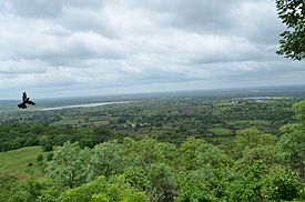
 View from Ananthagiri Hills | |
| Highest point | |
| Coordinates | 17°18′43″N 77°51′47″E / 17.312°N 77.863°E |
| Naming | |
| Language of name | Sanskrit |
| Geography | |
| Location | Telangana, India |
| Climbing | |
| Easiest route | Hyderabad |
Ananthagiri Hills is located in Vikarabad district,[1] Telangana, India.[2][3][4] The water flows from these hills to Osman Sagar, also known as Gandipet lake, and Himayathsagar.
It is one of the dense forests in Telangana. Ananthagiri Temple is located in this forested area. It is the birthplace of Musi river, also called as Muchkunda River, which flows through Hyderabad, 5 km from Vikarabad.


It is one of the earliest habitat areas. Ancient caves, medieval fort structures and temple shows the antiquity of this area.
- ^ "Ananthagiri Hills Resort". Retrieved 24 May 2015.
- ^ "Ananthagiri Hills to be developed into resort". The Hindu. 5 September 2006. Archived from the original on 8 January 2008. Retrieved 17 January 2019.
- ^ "Plan to develop Ananthagiri Hills into tourist resort". The Hindu. 8 September 2006. Retrieved 17 January 2019.
- ^ The Hindu : Andhra Pradesh News : Bauxite deals smack of graft: Naidu
