Back انرلی AZB Anerley Basque انرلی Persian Anerley French ऐनर्ली Hindi Anerley Italian Anerley NB انرلی، لندن Urdu 阿納利 Chinese
| Anerley | |
|---|---|
| Town | |
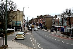
 Anerley Road 2010 | |
Location within Greater London | |
| OS grid reference | TQ345695 |
| • Charing Cross | 7.0 mi (11.3 km) NNW |
| London borough | |
| Ceremonial county | Greater London |
| Region | |
| Country | England |
| Sovereign state | United Kingdom |
| Post town | LONDON |
| Postcode district | SE20 |
| Dialling code | 020 |
| Police | Metropolitan |
| Fire | London |
| Ambulance | London |
| UK Parliament | |
| London Assembly | |
Anerley (/ˈænərli/) is suburb of south east London, England, within the London Borough of Bromley. It is located 7 miles (11 km) south south-east of Charing Cross, to the south of Upper Norwood, west of Penge, north of Elmers End and east of South Norwood. The northern edge of Anerley contains part of the area commonly known as Crystal Palace, and the site of the ancient Vicar's Oak where the London boroughs of Bromley, Croydon, Lambeth and Southwark meet,[1] with Lewisham 800 yards (740m) away.
- ^ "Replace The Vicar's Oak". www.norwoodsociety.co.uk. Retrieved 3 October 2024.
