Back Anjidiv Catalan Anjidiv Island CEB Angediva German Isla Anjadip Spanish Anjediva (uhartea) Basque Anjidiv French Anjediva GOM Pulau Anjadip ID Angediva Italian ಅಂಜದೀವ್ Kannada
Anjediva
Ilha de Angediva | |
|---|---|
Island | |
 Location of Anjediva (red) in Canacona (pink) | |
| Coordinates: 14°45′39″N 74°06′41″E / 14.760886°N 74.111258°E | |
| Country | |
| State | Goa |
| District | South Goa |
| Sub District | Canacona |
| Portuguese Establishment | before 1498 |
| Government | |
| • Type | Indian Navy |
| Area | |
| • Total | 1.5 km2 (0.6 sq mi) |
| Elevation | 8 m (26 ft) |
| Population (2011) | |
| • Total | 0 |
| • Density | 0.0/km2 (0.0/sq mi) |
| Time zone | UTC+5:30 (IST) |
Native name: Ilha de Angediva | |
|---|---|
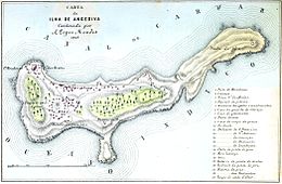
 A map of Anjediva in 1885 | |
 | |
| Geography | |
| Location | Arabian Sea |
| Area | 1.5 km2 (0.58 sq mi) |
| Length | 1.5 km (0.93 mi) |
| Width | 0.25 km (0.155 mi) |
| Coastline | 0.070 km (0.0435 mi) |
| Highest elevation | 8 m (26 ft) |
| Administration | |
India | |
| State | Goa |
| District | South Goa |
| Sub District | Canacona |
| Demographics | |
| Population | 0 (2011) |
| Pop. density | 0/km2 (0/sq mi) |
| Ethnic groups | Goan Catholics (now resettled) |
Anjediva Island (also Anjadip Island) (Goan Konkani: Anjadiv; Portuguese: Ilha de Angediva) is an Indian island in the Arabian Sea. It sits off the coast of Canacona, Goa. It is politically part of Goa state, geographically the nearest mainland is the coastal Kanara subregion of Carnataca.
The island is about 1.8 kilometres (1 mile) south of Goa, and extends over 1.5 square kilometres (1 square mile). It was part of the Portuguese Indian settlements until 1961, following the annexation of Goa and Damaon the place was turned into a military base, after which the civilian population was resettled to India or returned to Portugal.
The island is home to the Portuguese-built Anjediva fortress, which houses the shrines of Our Lady of Brotas and São Francisco de Assis. The island is connected to the mainland by a breakwater and is part of INS Kadamba Naval Base, on the outskirts of the city of Karwar and hence under the jurisdiction of the Indian Navy.
