Back آناندیل، نیو ساوت ولز Persian Annandale (Nouvelle-Galles du Sud) French אננדייל HE Annandale, New South Wales ID Annandale (Nuovo Galles del Sud) Italian Annandale (Sydney) Polish Annandale, New South Wales Romanian Annandale, New South Wales Swedish آنندیل، نیوساؤتھ ویلز Urdu 晏蘭爹 (新南威爾斯州) Chinese
| Annandale Sydney, New South Wales | |||||||||||||||
|---|---|---|---|---|---|---|---|---|---|---|---|---|---|---|---|
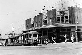
 Former tram service, corner of Booth and Johnston Streets 1955 | |||||||||||||||
 | |||||||||||||||
| Coordinates | 33°52′53″S 151°10′15″E / 33.88139°S 151.17083°E | ||||||||||||||
| Population | 9,487 (2021 census)[1] | ||||||||||||||
| • Density | 6,367/km2 (16,490/sq mi) | ||||||||||||||
| Established | 1823 | ||||||||||||||
| Postcode(s) | 2038 | ||||||||||||||
| Elevation | 31 m (102 ft) | ||||||||||||||
| Area | 1.49 km2 (0.6 sq mi) | ||||||||||||||
| Location | 5 km (3 mi) west of Sydney CBD | ||||||||||||||
| LGA(s) | Inner West Council | ||||||||||||||
| State electorate(s) | Balmain | ||||||||||||||
| Federal division(s) | |||||||||||||||
| |||||||||||||||

Annandale is a suburb in the Inner West[2] of Sydney, in the state of New South Wales, Australia. Annandale is located within 5 kilometres west of the Sydney central business district and is part of the local government area of the Inner West Council.[3] Annandale's northern end lies on Rozelle Bay, which is on Sydney Harbour. Glebe lies to its east, Lilyfield and Leichhardt to its west and Stanmore and Camperdown to its south.
- ^ Australian Bureau of Statistics (28 June 2022). "Annandale". 2021 Census QuickStats. Retrieved 12 November 2024.
- ^ Australian Suburb Guide: Sydney Inner West Archived 26 December 2012 at the Wayback Machine Retrieved 7 August 2013.
- ^ Gregory's Sydney Street Directory, Gregory's Publishing Company, 2007
