Back Antelope Island (pulo sa Tinipong Bansa, Utah, Davis County) CEB Antelope Island (Utah) German Isla Antílope Spanish Antelope Island Dutch Ilha de Antelope Portuguese Антелоп (остров) Russian Kisiwa cha Antelope Swahili
| Antelope Island State Park | |
|---|---|
| Pa'ri-bi-na | |
 View from Buffalo Point, Antelope Island | |
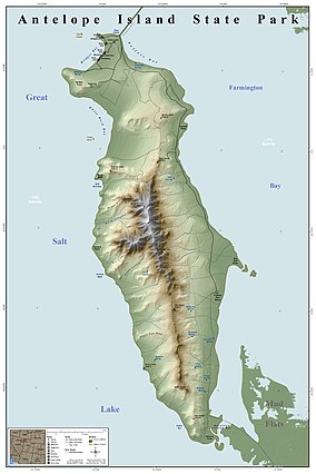
 Map of Antelope Island State Park | |
| Location | Davis County, Utah, United States |
| Coordinates | 40°57′30″N 112°12′50″W / 40.95833°N 112.21389°W |
| Length | 24 km (15 mi) |
| Width | 7.8 km (4.8 mi) |
| Area | 109 km2 (42 sq mi) |
| Elevation | 5,325 ft (1,623 m)[1] |
| Max. elevation | Frary Peak 6,596 ft (2,010 m)[2] |
| Min. elevation | 4,200 ft (1,300 m) at the shore[2] |
| Established | 1969[3] |
| Named for | Antelope Island |
| Visitors | 885,078 (in 2022)[4] |
| Governing body | Utah State Parks |
| Website | stateparks |
Antelope Island, with an area of 42 square miles (109 km2), is the largest of ten islands located within the Great Salt Lake in Utah. The island lies in the southeastern portion of the lake, near Salt Lake City and Davis County, and becomes a peninsula when the lake is at extremely low levels. It is protected as Antelope Island State Park.
The first known non-natives to visit the island were John C. Frémont and Kit Carson during exploration of the Great Salt Lake in 1845, who "rode on horseback over salt from the thickness of a wafer to twelve inches" and "were informed by the Indians that there was an abundance of fresh water on it and plenty of antelope".[5] It is said they shot a pronghorn antelope on the island, and in gratitude for the meat, they named it Antelope Island.
Antelope Island holds populations of pronghorn, bighorn sheep, American bison, porcupine, badger, coyote, bobcat, mule deer, and millions of waterfowl. The bison were introduced to the island in 1893, and the Antelope Island bison herd has proven to be a valuable genetic pool for bison breeding and conservation purposes. The bison do well, because much of the island is covered by dry, native grassland.
The geology of Antelope Island consists mostly of alluvial plains with prairie grassland on the north, east and south of the island, along with a mountainous central area of older Precambrian metamorphic and igneous rocks and late Precambrian to Paleozoic sedimentary rocks, covered by a thin layer of Quaternary lake deposits, colluvium and alluvium.[6] The Precambrian deposits on Antelope Island are some of the oldest rocks in the United States, older even than the Precambrian rocks at the bottom of the Grand Canyon.
- ^ "Antelope Island". Geographic Names Information System. United States Geological Survey. December 31, 1979. Retrieved 2010-01-07.
- ^ a b "Antelope Island State Parks - Discover". Utah State Parks. Retrieved 2024-03-17.
- ^ "Antelope Island - History" (PDF). stateparks.utah.gov. 2012-08-20. p. 5. Retrieved 17 March 2024.
- ^ "Park Visitation Data". Utah State Parks. July 6, 2023.
- ^ Carson, K., Autobiography, 1935, Lincoln: University of Nebraska Press, ISBN 0803250312, p.89
- ^ "Antelope Island Field Trip: Physiography". Weber State University Department of Botany. Archived from the original on 2003-03-29.