Back Arcis-le-Ponsart ALS Arcis-le-Ponsart AST Arcis-le-Ponsart Catalan АгӀси-ле-ПонсагӀ CE Arcis-le-Ponsart CEB Arcis-le-Ponsart German Arcis-le-Ponsart Spanish Arcis-le-Ponsart Basque آرسی-له-پونسارت Persian Arcis-le-Ponsart French
Arcis-le-Ponsart | |
|---|---|
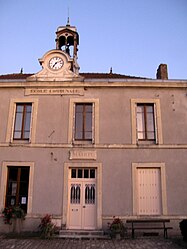
 The town hall in Arcis-le-Ponsart | |
| Coordinates: 49°14′09″N 3°41′40″E / 49.2358°N 3.6944°E | |
| Country | France |
| Region | Grand Est |
| Department | Marne |
| Arrondissement | Reims |
| Canton | Fismes-Montagne de Reims |
| Intercommunality | CU Grand Reims |
| Government | |
| • Mayor (2020–2026) | Jean-Luc Dubois[1] |
| Area 1 | 15.43 km2 (5.96 sq mi) |
| Population (2021)[2] | 287 |
| • Density | 19/km2 (48/sq mi) |
| Time zone | UTC+01:00 (CET) |
| • Summer (DST) | UTC+02:00 (CEST) |
| INSEE/Postal code | 51014 /51170 |
| Elevation | 100–248 m (328–814 ft) |
| 1 French Land Register data, which excludes lakes, ponds, glaciers > 1 km2 (0.386 sq mi or 247 acres) and river estuaries. | |
Arcis-le-Ponsart (French pronunciation: [aʁsi lə pɔ̃saʁ]) is a commune in the Marne department in northeastern France. It is located along the D25 road, south of Courville, 32.2 kilometres (20.0 mi) by road southwest of Reims. The commune of Arcis-le-Ponsart has an area of 15.4 square kilometres (5.9 sq mi). The local economy is mainly agricultural based. Igny Abbey lies in this commune.
- ^ "Répertoire national des élus: les maires". data.gouv.fr, Plateforme ouverte des données publiques françaises (in French). 2 December 2020.
- ^ "Populations légales 2021" (in French). The National Institute of Statistics and Economic Studies. 28 December 2023.


