| Arkansas Valley ecoregion | |
|---|---|
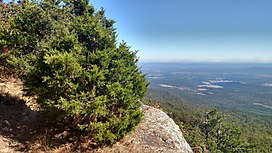
 View from Mount Magazine, the highest point in Arkansas, looking down upon the low valleys and hills of the Arkansas Valley | |
 Level III ecoregions in the region, with the Arkansas Valley ecoregion marked as (37) (full map) | |
| Ecology | |
| Borders | |
| Geography | |
| Area | 28,422 km2 (10,974 sq mi) |
| Country | United States |
| States |
|
| Climate type | Humid subtropical (Cfa) |
The Arkansas Valley is a Level III ecoregion designated by the Environmental Protection Agency (EPA) in the U.S. states of Arkansas and Oklahoma. It parallels the Arkansas River between the flat plains of western Oklahoma and the Arkansas Delta, dividing the Ozarks and the Ouachita Mountains with the broad valleys created by the river's floodplain, occasionally interrupted by low hills, scattered ridges, and mountains. In Arkansas, the region is often known as the Arkansas River Valley (or just River Valley), especially when describing the history and culture of the region.
Arkansas Valley is a synclinal and alluvial valley lying between the Ozark Highlands and the Ouachita Mountains. The Arkansas Valley is, characteristically, diverse and transitional. It generally coincides with the Arkoma Basin, an oil and gas province, that developed as sand and mud were deposited in a depression north of the rising Ouachita Mountains during the Mississippian and Pennsylvanian eras. The Arkansas Valley contains plains, hills, floodplains, terraces, and scattered mountains. It is largely underlain by interbedded Pennsylvanian sandstone, shale, and siltstone. Prior to the 19th century, uplands were dominated by a mix of forest, woodland, savanna, and prairie whereas floodplains and lower terraces were covered by bottomland deciduous forest. Today, less rugged upland areas have been cleared for pastureland or hayland. Poultry and livestock farming are important land uses. Water quality is generally good and influenced more by land use activities than by soils or geology; average stream gradients and dissolved oxygen levels are lower in the Arkansas Valley than in the Ouachita Mountains or Ozark Highlands, whereas turbidity, total suspended solids, total organic carbon, total phosphorus, and biochemical oxygen demand values are typically higher. The Arkansas River is continuously turbid. Summer flow in smaller streams is typically limited or nonexistent. Fish communities characteristically contain a substantial proportion of sensitive species; a sunfish- and minnowdominated community exists along with substantial proportions of darters and catfishes (particularly madtoms).
The Arkansas Valley ecoregion has been subdivided into five Level IV ecoregions.[1][2]
- ^
 This article incorporates public domain material from Woods, A.J.; Foti, T.L.; Chapman, S.S.; Omernik, J.M.; et al. Ecoregions of Arkansas (PDF). United States Geological Survey. (color poster with map, descriptive text, summary tables, and photographs).
- ^
 This article incorporates public domain material from Woods, A.J.; Omernik, J.M.; Butler, D.R.; Ford, J.G.; et al. Ecoregions of Oklahoma (PDF). United States Geological Survey. Retrieved January 18, 2018. (color poster with map, descriptive text, summary tables, and photographs).
