| Arn Gill | |
|---|---|
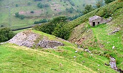
 Arn Gill: ravine with former lead mine | |
| Etymology | Arn = "eagle".[1] Gill = river-cut ravine (northern England).[2] |
| Location | |
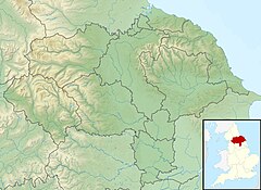
| Country | England |
| County | North Yorkshire |
| Physical characteristics | |
| Source | Arn Gill Head, Swaledale |
| • coordinates | 54°23′19.8″N 02°07′57.7″W / 54.388833°N 2.132694°W |
| Mouth | |
• location | River Swale |
• coordinates | 54°23′18.8″N 02°08′34.2″W / 54.388556°N 2.142833°W |
| Basin features | |
| Landmarks | Former lead mine and spoil heap |
| Waterfalls | There are waterfalls near the outfall to the River Swale. |
| Tributary of River Swale | |
Arn Gill is a ravine or gully containing a beck of the same name, near the village of Muker in Swaledale, North Yorkshire, England. The ravine and beck run steeply downhill from the stream's source in Arn Gill Head, and the beck disgorges into the River Swale below.
The ravine contains remnants of the former Adelaide Level lead mine, which is named after Lady Adelaide Lamont, a descendant of Judge Jeffreys. In 1865 a strike was made there, which yielded about £12,000 (equivalent to £1,449,217 in 2023) worth of galena or lead ore. The mine closed in 1920. Miners worked in bad conditions in North Yorkshire lead mines during the Adelaide Level's era, with over 62% of local mines having extremely impure air. The most common occupational disease for miners was silicosis.

