Back منطقة أشوك نجر Arabic اشوك نجر ARZ अशोक नगर जिला Bihari অশোকনগর জেলা Bengali/Bangla Ashoknagar (distrito) CEB Ashoknagar (Distrikt) German Distrito de Ashok Nagar Spanish Ashoknagar barrutia Basque بخش آشوکنگار Persian District d'Ashok Nagar French
Ashoknagar district (Pachhaar) | |
|---|---|
Clockwise from top-left: Chanderi fort, Toteshwara Mahadev Temple in Kadwaha, Rakhetra Bhiyadant Caves, Betwa River near Ashoknagar, Kuti Temples in Thubon, vindyvashni temple and many other temple in tumen, | |
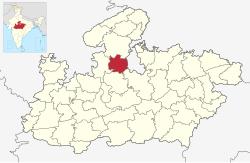
 Location of Ashoknagar district in Madhya Pradesh | |
| Coordinates (Ashoknagar): 24°34′48″N 77°43′48″E / 24.58000°N 77.73000°E | |
| Country | |
| State | Madhya Pradesh |
| Division | Gwalior division |
| Headquarters | Ashoknagar |
| Government | |
| • Lok Sabha constituencies | Guna |
| Area | |
| • Total | 4,673.94 km2 (1,804.62 sq mi) |
| Population (2011) | |
| • Total | 845,071 |
| • Density | 180/km2 (470/sq mi) |
| Demographics | |
| • Literacy | 67.90 |
| • Sex ratio | 900 |
| Time zone | UTC+05:30 (IST) |
| Website | ashoknagar |
Ashoknagar District is a district of Madhya Pradesh state in central India. The city of Ashoknagar is the administrative headquarters of the district. Ashoknagar district was formed in 2003.


