Back نهر اشتابولا ARZ Ashtabula River CEB Ashtabula River German Ashtabula (rivier) Frisian Ashtabula River Polish 阿什特比拉河 Chinese
| Ashtabula River | |
|---|---|
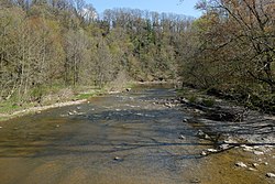
 The Ashtabula River as viewed from the Riverview Covered Bridge | |
 Map of the Ashtabula River and its watershed | |
| Location | |
| Country | United States of America |
| State | Ohio |
| County | Ashtabula County |
| Physical characteristics | |
| Source | |
| • location | Confluence of east and west branches in Monroe Township, Ashtabula County |
| • coordinates | 41°48′51″N 80°36′57″W / 41.81417°N 80.61583°W[2] |
| • elevation | 850 feet (260 m)[1] |
| Mouth | |
• location | Lake Erie at Ashtabula, Ohio |
• coordinates | 41°54′36″N 80°47′55″W / 41.91000°N 80.79861°W[2] |
• elevation | 571 feet (174 m)[2] |
| Length | 40 miles (64 km)[citation needed] |
| Basin size | 137 square miles (350 km2)[3] |
| Discharge | |
| • location | mouth |
| • average | 220.72 cu ft/s (6.250 m3/s) (estimate)[4] |
The Ashtabula River[5] is a river located northeast of Cleveland in Ohio. The river flows into Lake Erie at the city of Ashtabula, Ohio. It is 40 miles (64 km) in length and drains 137 square miles (350 km2).[citation needed]
- ^ United States Geological Survey. Pierpont quadrangle, Ohio. 1:24,000. 7.5 Minute Series. Washington D.C.: USGS, 1994.
- ^ a b c U.S. Geological Survey Geographic Names Information System: Ashtabula River
- ^ "Map of Ohio watersheds". Archived from the original on 2007-03-11.
- ^ United States Environmental Protection Agency. "Watershed Report: Ashtabula River". watersgeo.epa.gov. Archived from the original on 2021-07-04. Retrieved 2021-07-04.
- ^ United States Geological Survey Hydrological Unit Code: 04-11-00-03-050