Back Asop de Beòcia Catalan Asopós Potamós (suba sa Gresya, Attica) CEB Asopos (Böotien) German Ασωπός (ποταμός) Greek Asopós (Boiotia) Finnish Asopós (Béotie) French Asopo (Beozia) Italian アソポス川 (ボイオティア) Japanese Asopos (rzeka w Beocji) Polish Асопос (река, впадает в Эгейское море) Russian
| Asopos | |
|---|---|
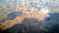
 The Asopos river appears in the top left corner of this view of the battlefield of the Battle of Plataea. | |
 | |
| Location | |
| Country | Greece |
| Physical characteristics | |
| Source | |
| • location | Cithaeron mountain |
| Mouth | |
• location | South Euboean Gulf |
• coordinates | 38°20′7″N 23°44′28″E / 38.33528°N 23.74111°E |
| Length | 57 km (35 mi) |
| Basin size | 718 km2 (277 sq mi) |
The Asopos (Greek: Ασωπός, referred to in Latin sources as Asopus) is a river in Boeotia and northern Attica, Greece. In antiquity, it formed the border between the cities of Thebes and Plataea.[1] The Battle of Plataea was fought on its banks. According to Pausanias (5.14.3) the Boeotian Asopus can produce the tallest reeds of any river.
Its source is on the northern slope of the Cithaeron mountain, southwest of Thebes. It empties into the South Euboean Gulf, near Skala Oropou. Its total length is 57 km. Its basin is 718 km2.[2][3] The Asopos flows along the following places, from the source downstream: Lefktra, Agios Thomas, Oinofyta, Sykamino, Skala Oropou. The river is polluted with hexavalent chromium due to industrial activity.[2]
- ^ Pausanias, Description of Greece 9.4.4
- ^ a b Vasilatos, Ch. (2008). "Hexavalent chromium and other toxic elements in natural waters in the Thiva – Tanagra – Malakasa Basin, Greece" (PDF). Hellenic Journal of Geosciences. 43: 57–66. Retrieved 13 October 2013.
- ^ "Preliminary Flood Risk Assessment" (in Greek). Ministry of Environment, Energy and Climate Change. p. 61. Archived from the original on 15 February 2020.