This article needs additional citations for verification. (February 2024) |
Atsumi
渥美町 | |
|---|---|
Former municipality | |
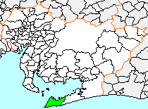
 Location of Atsumi in Aichi Prefecture | |
| Coordinates: 34°42′34.77″N 137°10′54.3″E / 34.7096583°N 137.181750°E | |
| Country | Japan |
| Region | Chūbu (Tōkai) |
| Prefecture | Aichi Prefecture |
| District | Atsumi |
| Merged | October 1, 2005 (now part of Tahara) |
| Area | |
| • Total | 82.18 km2 (31.73 sq mi) |
| Population (July 31, 2005) | |
| • Total | 22,472 |
| • Density | 436.77/km2 (1,131.2/sq mi) |
| Time zone | UTC+09:00 (JST) |
| Symbols | |
| Bird | Hawk |
| Flower | Chrysanthemum |
| Tree | Pine |
Atsumi (渥美町, Atsumi-chō) was a town located in Atsumi District, Aichi Prefecture, Japan.
As of July 31, 2005, the town had an estimated population of 22,472 and a population density of 436.77 persons per km2. Its total area was 82.18 km2.


