Back أوبورن (نبراسكا) Arabic اوبورن (نيهاما, نبراسكا) ARZ آبورن، نبراسکا AZB Auburn (Nebraska) Catalan Оберн (Небраска) CE Auburn (kapital sa kondado sa Tinipong Bansa, Nebraska) CEB Auburn, Nebraska Welsh Auburn (Nebraska) Spanish Auburn (Nebraska) Basque اوبرن، نبراسکا Persian
Auburn, Nebraska | |
|---|---|
 Central Avenue: U.S. Highway 136 | |
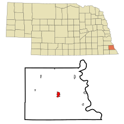
 Location of Auburn, Nebraska | |
| Coordinates: 40°23′22″N 95°50′37″W / 40.38944°N 95.84361°W | |
| Country | United States |
| State | Nebraska |
| County | Nemaha |
| Area | |
| • Total | 2.19 sq mi (5.66 km2) |
| • Land | 2.19 sq mi (5.66 km2) |
| • Water | 0.00 sq mi (0.00 km2) |
| Elevation | 1,027 ft (313 m) |
| Population (2020) | |
| • Total | 3,470 |
| • Density | 1,587.37/sq mi (612.99/km2) |
| Time zone | UTC−6 (Central (CST)) |
| • Summer (DST) | UTC−5 (CDT) |
| ZIP code | 68305 |
| Area code | 402 |
| FIPS code | 31-02655 |
| GNIS feature ID | 2394026[2] |
| Website | auburn.ne.gov |
Auburn is a city in Nemaha County, Nebraska, United States, and its county seat.[3] The population was 3,470 at the 2020 census.
- ^ "ArcGIS REST Services Directory". United States Census Bureau. Retrieved September 18, 2022.
- ^ a b U.S. Geological Survey Geographic Names Information System: Auburn, Nebraska
- ^ "Find a County". National Association of Counties. Archived from the original on May 31, 2011. Retrieved June 7, 2011.