Babonneau | |
|---|---|
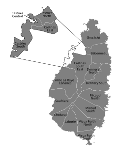
 Electoral boundaries of Saint Lucia | |
| Coordinates: 14°00′13″N 60°56′36″W / 14.00374°N 60.94324°W[1] | |
| Country | Saint Lucia |
| District | Castries District |
| Elevation | 180 m (590 ft) |
Babonneau is one of the regions of the Caribbean island nation of Saint Lucia. Babonneau is located in the north of the island in the Castries Quarter. There are extensive rain forests in the region, which is an important source of fresh water for Saint Lucia. Babonneau is also an electoral constituency of Saint Lucia represented in the House of Assembly of Saint Lucia, which extends into Gros Islet District.[1][2]
- ^ a b c "Babonneau". GeoNames. Retrieved August 11, 2021.
- ^ "Vulnerability and Capacity Assessment, Babonneau, Saint Lucia" (PDF). Prepare Center. Retrieved August 12, 2021.

