Back منطقة بانج راك Arabic খেত ব্যাং রাক BPY Khet Bang Rak CEB Bang Rak German Bang Rak Estonian Bang Rak French באנג ראק (מחוז) HE Bang Rak Italian バーンラック区 Japanese 방락 Korean
Bang Rak
บางรัก | |
|---|---|
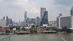
 Skyline of Bang Rak, from across the Chao Phraya River | |
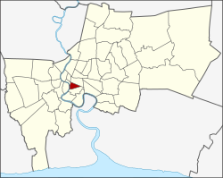
 Location in Bangkok | |
| Coordinates (district office): 13°43′50″N 100°31′25″E / 13.73056°N 100.52361°E | |
| Country | Thailand |
| Province | Bangkok |
| Seat | Si Phraya |
| Khwaeng | 5 |
| Area | |
| • Total | 5.54 km2 (2.14 sq mi) |
| Population (2019)[1] | |
| • Total | 48,227 |
| • Density | 8,700/km2 (23,000/sq mi) |
| Postal code | 10500 |
| Geocode | 1004 |
| Website | www |
Bang Rak (Thai: บางรัก, pronounced [bāːŋ rák]) is one of the fifty districts (khet) of Bangkok, Thailand. It lies on the eastern bank of the Chao Phraya River, beyond Khlong Phadung Krung Kasem, which marked the old city boundary. Originating from riverside settlements dating from before the city's foundation, Bang Rak grew inland as new roads and canals were constructed through the area during the second half of the nineteenth century and the early twentieth, attracting communities of expatriates and developing into a major commercial district.
Bangkok's rapid economic growth in the late twentieth century saw the areas along Si Lom and Sathon roads transformed into one of the city's main business districts, teeming with skyscrapers. The district, officially recognised at least since 1908, covers an area of 5.54 square kilometres (2.14 sq mi), and has a registered population of 48,227 (as of 2019).
- ^ "จำนวนประชากร". Official Statistics Registration Systems. Department of Provincial Administration, Ministry of Internal Affairs. Retrieved 16 January 2021.