Back نهر باني Arabic نهر بانى ARZ Бані Byelorussian Бани Bulgarian Riu Bani Catalan Bani (suba sa Mali, Mopti Region, lat 14,48, long -4,21) CEB Bani (řeka) Czech Бани (юханшыв) CV Afon Bani Welsh Bani (Fluss) German


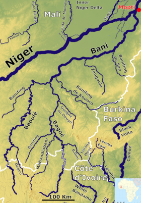
The Bani River is the principal tributary of the Niger River in Mali.[3] The river is formed from the confluence of the Baoulé and Bagoé rivers some 160 km (99 mi) east of Bamako and it merges with the Niger near Mopti. Its length is about 1,100 km (680 mi).
- ^ The Douna Hydrometric Station is located at 13°12′50″N 5°54′11″W / 13.213853°N 5.903105°W near the bridge over the river carrying the RN6 highway from Ségou to Bla.
- ^ Data from UNH/GRDC Composite Runoff Fields V 1.0.
- ^ Bani means "little river" in Mande languages. Delafosse, Maurice (1912), Haut-Sénégal-Niger. Volume 1 Le Pays, les Peuples, les Langues (in French), Paris: Émile Larose, p. 69.
