| Bargara Queensland | |||||||||||||||
|---|---|---|---|---|---|---|---|---|---|---|---|---|---|---|---|
 | |||||||||||||||
| Coordinates | 24°49′14″S 152°27′45″E / 24.8205°S 152.4625°E | ||||||||||||||
| Population | 8,883 (2021 census)[1] | ||||||||||||||
| • Density | 955/km2 (2,474/sq mi) | ||||||||||||||
| Postcode(s) | 4670 | ||||||||||||||
| Elevation | 0–10 m (0–33 ft) | ||||||||||||||
| Area | 9.3 km2 (3.6 sq mi) | ||||||||||||||
| Time zone | AEST (UTC+10:00) | ||||||||||||||
| Location |
| ||||||||||||||
| LGA(s) | Bundaberg Region | ||||||||||||||
| State electorate(s) | Burnett | ||||||||||||||
| Federal division(s) | Hinkler | ||||||||||||||
| |||||||||||||||
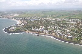
Bargara /bəˈɡɑːrə/[2] is a coastal town and suburb in the Bundaberg Region, Queensland, Australia.[3][4] In the 2021 census, the suburb of Bargara had a population of 8,883 people.[1]
The town of Bargara lies 384 kilometres (239 mi) north of the state capital Brisbane and just 13 kilometres (8 mi) east of Bundaberg. Bargara is considered to be a satellite suburb of Bundaberg,[citation needed] with only sugar cane fields separating the two centres.
Nielson Park is a coastal town in the north of the locality (24°48′27″S 152°27′24″E / 24.8075°S 152.4566°E),[5] only 1.5 kilometres (0.93 mi) from the town of Bargara.
- ^ a b Cite error: The named reference
Census2021was invoked but never defined (see the help page). - ^ Macquarie Dictionary, Fourth Edition (2005). Melbourne, The Macquarie Library Pty Ltd. ISBN 1-876429-14-3
- ^ "Bargara – town in Bundaberg Region (entry 40971)". Queensland Place Names. Queensland Government. Retrieved 26 December 2020.
- ^ "Bargara – suburb in Bundaberg Region (entry 44684)". Queensland Place Names. Queensland Government. Retrieved 26 December 2020.
- ^ "Nielson Park – population centre in Bundaberg Regional (entry 48151)". Queensland Place Names. Queensland Government. Retrieved 26 December 2020.

