Back باربتا Arabic باربتا ARZ বৰপেটা জিলা Assamese बारपेटा जिला Bihari বড়পেটা জেলা Bengali/Bangla বড়পেটা BPY Barpeta (distrito) CEB Barpeta (Distrikt) German Distrito de Barpeta Spanish Barpeta barrutia Basque
Barpeta district | |
|---|---|
 | |
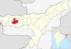
 Location in Assam | |
| Coordinates: 26°32′N 91°00′E / 26.533°N 91.000°E | |
| Country | |
| State | Assam |
| Division | Lower Assam |
| Headquarters | Barpeta |
| Government | |
| • Lok Sabha constituencies | Barpeta |
| • Vidhan Sabha constituencies | Sorbhog, Barpeta, Jania, Baghbar, Sarukhetri, Chenga |
| Area | |
| • Total | 2,764 km2 (1,067 sq mi) |
| Population (2011) | |
| • Total | 1,439,806 |
| • Density | 520/km2 (1,300/sq mi) |
| Time zone | UTC+05:30 (IST) |
| ISO 3166 code | IN-AS-BA |
| Website | https://barpeta.assam.gov.in/ |
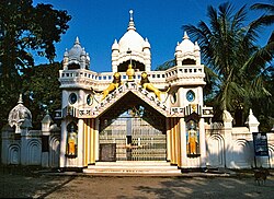
Barpeta district {Pron:bə(r)ˈpeɪtə or bə(r)ˈpi:tə} is an administrative district in the state of Assam in India. The district headquarters are located at Barpeta. The district occupies an area of 3,245 km2 (1,253 sq mi) and has a population of 1,642,420 (as of 2001).
