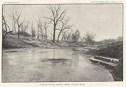
| Barton Creek | |
|---|---|
 Barton Creek in 1900[1] | |
 Barton creek watershed in Travis County | |
| Location | |
| Country | United States |
| State | Texas |
| Region | Texas Hill Country |
| Municipality | Austin |
| Physical characteristics | |
| Source | Hays County, Texas |
| • coordinates | 30°14′22.87″N 98°9′10.4″W / 30.2396861°N 98.152889°W |
| • elevation | 380 m (1,250 ft) |
| Mouth | Colorado River (Texas) |
• location | Lady Bird Lake |
• coordinates | 30°16′1.46″N 97°45′40.63″W / 30.2670722°N 97.7612861°W |
• elevation | 130 m (430 ft) |
| Length | 64 km (40 mi) |
| Discharge | |
| • average | 1.84 m3/s (65 cu ft/s) |
Barton Creek is a tributary that feeds the Colorado River as it flows through the Texas Hill Country. The creek passes through some of the more scenic areas in Greater Austin, surrounded in many parts by a greenbelt of protected lands that serves as a habitat for many indigenous species of flora and fauna.[2] The creek passes through Barton Creek Greenbelt and is fed by Barton Springs.
- ^ Hill, R.T. 1901. Geography and geology of the Black and Grand Prairies, Texas with detailed descriptions of the Cretaceous formations and special reference to artesian waters. In: Walcott, C.D. (Director), Twenty-First Annual Report of the United States Geological Survey to the Secretary of the Interior (1899-1900), Part VII-Texas, Washington: Government Printing Office, 662 pp.
- ^ "BARTON CREEK (HAYS COUNTY)". Handbook of Texas Online. Texas State Historical Association. Retrieved 16 November 2015.
