42°6′47″N 73°29′43″W / 42.11306°N 73.49528°W
| Bash Bish Falls | |||
|---|---|---|---|
| Location: | Mount Washington, Massachusetts, US | ||
| Type: | Cascade | ||
| Total height: | 60 feet (18 m) | ||
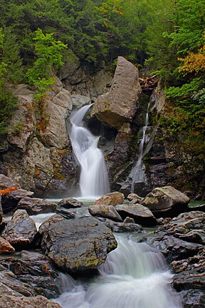
Bash Bish Falls, a waterfall in Bash Bish Falls State Park in the Taconic Mountains of southwestern Massachusetts (Berkshire County), is the highest waterfall in the state.[citation needed] The falls are made up of a series of cascades, nearly 200 feet (61 m) in total. The final cascade is split into twin falls by a jutting rock, dropping in a 59-foot (18 m) "V" over boulders to a serene pool below.[1]

The waters of Bash Bish Falls begin at a spring in Mount Washington and after the falls, Bash Bish Brook has cut a 1,000 -foot deep valley on its way westward to adjacent New York State. The brook cuts between Bash Bish Mountain (elevation 1890) and Cedar Mountain (elevation 1883) creating a dramatic gorge that frames the falls.[2]
Bash Bish Falls State Park is located next to both Massachusetts' 4,000-acre (16 km2) Mount Washington State Forest and New York's 5,000-acre (20 km2) Taconic State Park.[3]
- ^ "Bash Bish Falls". Scenic Hudson.
- ^ Laubach, Rene (1997). A Guide to Natural Places in the Berkshire Hills, revised. Berkshire House. pp. 33–39.
- ^ "Bash Bish Falls State Park, Mt. Washington, Massachusetts". Housatonic Heritage.

