Back بنسلي (فرجينيا) Arabic بنسلی، ویرجینیا AZB Bensley Catalan Бенсли (Виргини) CE Bensley (lungsod) CEB Bensley, Virginia Welsh Bensley (Virginia) Spanish Bensley (Virginia) Basque بنسلی، ویرجینیا Persian Bensley (Virginia) Italian
Bensley, Virginia | |
|---|---|
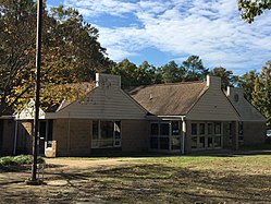
 Bensley community building | |
 Location of Bensley, Virginia | |
| Coordinates: 37°26′56″N 77°26′44″W / 37.44889°N 77.44556°W | |
| Country | United States |
| State | Virginia |
| County | Chesterfield |
| Area | |
| • Total | 2.9 sq mi (7.5 km2) |
| • Land | 2.9 sq mi (7.4 km2) |
| • Water | 0.04 sq mi (0.1 km2) |
| Elevation | 56 ft (17 m) |
| Population (2010) | |
| • Total | 5,819 |
| • Density | 2,000/sq mi (780/km2) |
| Time zone | UTC−5 (Eastern (EST)) |
| • Summer (DST) | UTC−4 (EDT) |
| FIPS code | 51-06728[1] |
| GNIS feature ID | 1867584[2] |
Bensley is a census-designated place (CDP) in Chesterfield County, Virginia, United States. It is an inner suburb of Richmond, Virginia. The population was 5,819 at the 2010 census.[3] Bensley Community building is inside of Bensley park. The community building is outside of Bensley, setting in walking distance of the CDP. The community is an old village with no active government. The community is over 100 years old. A new police substation in the village is next to the old Bensley Bermuda Rescue Squad, near DuPont Spruance.
- ^ "U.S. Census website". United States Census Bureau. Retrieved January 31, 2008.
- ^ "US Board on Geographic Names". United States Geological Survey. October 25, 2007. Retrieved January 31, 2008.
- ^ "Profile of General Population and Housing Characteristics: 2010 Demographic Profile Data (DP-1): Bensley CDP, Virginia". United States Census Bureau. Retrieved November 29, 2011.