Back Alpes de Berchtesgaden AN جبال الالب بيرشتسجادن ARZ Берхтесгаденски Алпи Bulgarian Berchtesgadener Alpen CEB Berchtesgadenské Alpy Czech Berchtesgaden Alperne Danish Berchtesgadener Alpen German Alpes de Berchtesgaden Spanish Berchtesgadeni Alpid Estonian برشتسگدن الپ Persian
| Berchtesgaden Alps | |
|---|---|
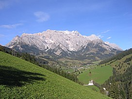
 The Hochkönig from the south | |
| Highest point | |
| Peak | Hochkönig |
| Elevation | 2,941 m (9,649 ft) |
| Coordinates | 47°25′13″N 13°3′45″E / 47.42028°N 13.06250°E |
| Dimensions | |
| Length | 45 km (28 mi) |
| Area | 1,089.0 km2 (420.5 sq mi) |
| Geography | |
| Countries | Germany and Austria |
| States | Bavaria and Salzburg |
| Parent range | Northern Limestone Alps Northern Salzburg Alps |
| Geology | |
| Age of rock | Triassic |
| Type of rock | Wetterstein limestone, Ramsau dolomite and Dachstein limestone |
The Berchtesgaden Alps (German: Berchtesgadener Alpen) are a mountain range of the Northern Limestone Alps, named after the market town of Berchtesgaden located in the centre. It is crossed by the Austria–Germany border: the central part belongs to the Berchtesgadener Land district of southeastern Bavaria, Germany, while the adjacent area in the north, east and south is part of the Austrian state of Salzburg (Salzburger Land).