Back Berliner Ringbahn Danish Berliner Ringbahn German Ringbahn de Berlín Spanish رینگبان برلین Persian Ringbahn Finnish Ringbahn de Berlin French Berliner Ringbahn Hungarian Ringbahn Italian ベルリン環状線 Japanese 베를린 순환선 Korean
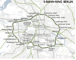
The Ringbahn (German for circle railway) is a 37.5 km (23.3 mi) long circle route around Berlin's inner city area, on the Berlin S-Bahn network. Its course is made up of a pair of tracks used by S-Bahn trains and another parallel pair of tracks used by various regional, long distance and freight trains. The S-Bahn lines S41 and S42 provide a closed-loop continuous service without termini. Lines S45, S46 and S47 use a section of the southern and western ring, while lines S8 and S85 use sections of the eastern ring. The combined number of passengers is about 400,000 passengers a day.[2] Due to its distinctive shape, the line is often referred to as the Hundekopf (Dog's Head).[3]
The Ringbahn is bisected by an east–west railway thoroughfare called the Stadtbahn (city railway), which crosses the Ringbahn from Westkreuz (Western Cross) to Ostkreuz (Eastern Cross), forming a Südring (Southern Ring) and a Nordring (Northern Ring). The north-south S-Bahn link (with the North-South S-Bahn-tunnel as its core) divides the Ringbahn into a Westring (Western Ring) and an Ostring (Eastern Ring), crossing at Gesundbrunnen station in the north and both Schöneberg station and Südkreuz in the south. These four sections served as tariff zones of the suburban fare structure before World War II. Over time, these four rings ceased to exist with the removal of track connections. Only at Westkreuz does an original such track remain, used only for utility purposes. At Ostkreuz, a newly-designed bypass provides access to southern branches without having to enter the station. Gesundbrunnen is not a typical crossing, but rather has parallel tracks that curve to the south after leaving the station, allowing trains to run towards Südkreuz.
The approximately 88-square-kilometre (34 sq mi) area encompassed by the Ringbahn comprises the "Berlin A" zone in the Verkehrsverbund Berlin-Brandenburg's fare structure. The Ringbahn also serves as the border for Berlin's low-emission zone, established on 1 January 2008.

- ^ Eisenbahnatlas Deutschland (German railway atlas). Schweers + Wall. 2009. pp. 128–9. ISBN 978-3-89494-139-0.
- ^ "Rekordfahrgastzahlen bei der S-Bahn" (in German). Deutsche Bahn AG.
- ^ "AUS DER GESCHICHTE DER BERLINER RINGBAHN Der "Hundekopf" entsteht wieder" (in German). Berliner Zeitung. 2001-09-13. pp. S 07.

