Back Bighorn Canyon National Recreation Area (parke sa Tinipong Bansa, Montana) CEB Bighorn Canyon National Recreation Area German Bighorn Canyon National Recreation Area French
| Bighorn Canyon National Recreation Area | |
|---|---|
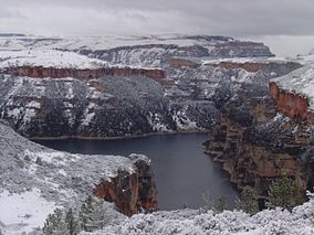
 Snowfall on the Bighorn Canyon in the North District | |
| Location | Big Horn and Carbon counties, Montana & Big Horn County, Wyoming, USA |
| Nearest city | Billings, Montana |
| Coordinates | 45°11′40″N 108°7′50″W / 45.19444°N 108.13056°W |
| Area | 120,296.22 acres (486.8215 km2)[1] |
| Established | October 15, 1966 |
| Visitors | 217,660 (in 2022)[2] |
| Governing body | National Park Service |
| Website | Bighorn Canyon National Recreation Area |


Bighorn Canyon National Recreation Area is a national recreation area established by an act of Congress on October 15, 1966, following the construction of the Yellowtail Dam by the Bureau of Reclamation. It is one of over 420 sites managed by the U.S. National Park Service. The recreation area spans 120,296.22 acres, straddling the border between Wyoming and Montana. It is divided into two distinct areas, the North District accessed via Fort Smith, Montana and the South District accessed through Lovell, Wyoming. There is no thru road inside the recreation area connecting the two districts. The Yellowtail Dam is located in the North District. It is named after the famous Crow leader Robert Yellowtail, harnesses the waters of the Bighorn River by turning that variable watercourse into Bighorn Lake. The lake extends 71 miles (114 km) through Wyoming and Montana, 55 miles (89 km) of which lie within the national recreation area.[3] The lake provides recreational boating, fishing, water skiing, kayaking, and birding opportunities to visitors. About one third of the park unit is located on the Crow Indian Reservation.[4] Nearly one-quarter of the Pryor Mountains Wild Horse Range lies within the Bighorn Canyon National Recreation Area.[5]
- ^ "Listing of acreage – December 31, 2011" (XLSX). Land Resource Division, National Park Service. Retrieved 2012-12-16. (National Park Service Acreage Reports)
- ^ "NPS Annual Recreation Visits Report". National Park Service. Retrieved 2023-08-05.
- ^ "Management: Bighorn Canyon National Recreation Area". National Park Service. Retrieved 2013-11-25.
- ^ "The National Parks Index 2009-2011". National Park Service. Archived from the original on 2013-12-03. Retrieved 2013-11-25.
- ^ "Wild Horses." Billings Field Office. Bureau of Land Management. United States Department of the Interior. May 2, 2011. Archived June 16, 2015, at the Wayback Machine Accessed 2011-05-18.

