Back Aeropuertu Toronto City Centre AST Billy Bishop Toronto City Airport CEB فڕۆکەخانەی شاری بیلی بیشۆپ تۆرۆنتۆ CKB Flughafen Toronto-City German Aeropuerto Toronto City Centre Spanish فرودگاه شهری بیلی بیشاپ تورنتو Persian Toronto Cityn lentoasema Finnish Aéroport Billy-Bishop de Toronto French Aeroporto da cidade de Toronto Billy Bishop Galician Bandar Udara Billy Bishop Kota Toronto ID
Billy Bishop Toronto City Airport | |||||||||||||||
|---|---|---|---|---|---|---|---|---|---|---|---|---|---|---|---|
 | |||||||||||||||
 | |||||||||||||||
| Summary | |||||||||||||||
| Airport type | Public | ||||||||||||||
| Owner/Operator | PortsToronto | ||||||||||||||
| Location | Toronto | ||||||||||||||
| Hub for | |||||||||||||||
| Time zone | EST (UTC−05:00) | ||||||||||||||
| • Summer (DST) | EDT (UTC−04:00) | ||||||||||||||
| Elevation AMSL | 252 ft / 77 m | ||||||||||||||
| Coordinates | 43°37′42″N 079°23′46″W / 43.62833°N 79.39611°W | ||||||||||||||
| Public transit access | |||||||||||||||
| Website | www | ||||||||||||||
| Map | |||||||||||||||
 | |||||||||||||||
| Runways | |||||||||||||||
| |||||||||||||||
| Statistics (2022) | |||||||||||||||
| |||||||||||||||
Sources: Canada Flight Supplement[1] Environment Canada[2] Movements from Statistics Canada[3] Passenger traffic from portstoronto.com[4] | |||||||||||||||
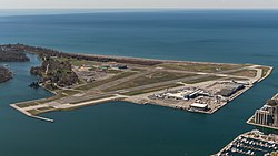
Billy Bishop Toronto City Airport (IATA: YTZ, ICAO: CYTZ) is a regional airport located on the Toronto Islands in Toronto, Ontario, Canada. It is often referred to as Toronto Island Airport and was previously known as Port George VI Island Airport and Toronto City Centre Airport. The airport's name honours Billy Bishop, the Canadian World War I flying ace and World War II Air Marshal. It is used by civil aviation, air ambulances, and regional airlines using turboprop planes. In 2022, it was ranked Canada's ninth-busiest airport.[5][6][7]
Conceived in the 1930s as the main airport for Toronto, the construction of the airport was completed in 1939 by the Toronto Harbour Commission (THC). At the same time, the THC built Malton Airport as an alternate. But nearby Malton (today Toronto Pearson International Airport) became Toronto's main passenger airline hub instead, leaving the island airport for general aviation and military purposes. During the 1940s and 1950s, several political leaders proposed an expansion of the island airport to enable scheduled passenger airlines and reduce the annual operating costs. Malton was sold in 1962 to the Government of Canada in exchange for an expansion and improvements to the island airport. After the expansion, civil flights increased to a peak of over 200,000 annual flights in the 1960s. Although regional airlines were introduced in the 1970s, the annual number of flights went into decline and closure was discussed. In 1983, a 50-year tripartite agreement between the Government of Canada, the City of Toronto government and the Harbour Commission, which limited noise and banned jet use for scheduled airlines, allowed airport operations to continue. In the 1990s, in an era of government cost-cutting, questions about the airport's future were raised again due to its annual deficit. At the same time, redevelopment was taking over north of the airport and several studies suggested that the airport was incompatible with development.
In 1999, the new Toronto Port Authority (TPA; renamed in 2015 as "PortsToronto") replaced the THC. The TPA's mandate was to make the port and airport self-sufficient and it determined that the airport needed to expand to end the annual subsidy. Although an expansion of the airport was and is politically controversial, the TPA has worked with new regional airline Porter Airlines since 2003 to increase scheduled carrier flights. Under the new financial model, carriers pay landing fees and departing passengers pay airport improvement fees to the TPA. Porter launched in 2006 and passenger volumes increased to the point that airport operations became self-sufficient by 2010. In 2010, Porter opened a new terminal. In 2015, a pedestrian tunnel to the airport was opened, after a previous plan to build a bridge was cancelled.
In 2013, Porter proposed expanding the airport further and modifying the operating agreement to allow it to use Bombardier CS100 jet planes at the airport. The proposal, estimated to cost CA$1 billion in public expenditure,[8] went to PortsToronto for further study. In November 2015, after the 2015 Canadian federal election, the new government announced that it would not re-open the tripartite agreement to allow jets.[9] Ports Toronto subsequently cancelled the expansion proposal studies. The airport is accessed via ferry or the 260-metre (850 ft) pedestrian tunnel that connects to the mainland.[10]
- ^ Cite error: The named reference
CFSwas invoked but never defined (see the help page). - ^ "Synoptic/Metstat Station Information". Archived from the original on June 27, 2013. Retrieved March 17, 2011.
- ^ "Aircraft movements, by class of operation, airports with NAV CANADA services and other selected airports, monthly". Statistics Canada. December 21, 2022. Retrieved May 7, 2023.
- ^ Cite error: The named reference
2022statswas invoked but never defined (see the help page). - ^ "Home | Billy Bishop Toronto City Airport". www.billybishopairport.com. Retrieved November 13, 2019.
- ^ "Aircraft movements, by class of operation and peak hour and peak day of movements, for airports with NAV CANADA towers, monthly". Statistics Canada. Retrieved May 18, 2022.
- ^ "Billy Bishop Airport". www.portstoronto.com. Archived from the original on March 14, 2016. Retrieved August 24, 2017.
- ^ Lu, Vanessa (September 15, 2015). "Report warns of high costs for jets at Billy Bishop". Toronto Star. Retrieved October 5, 2015.
- ^ "Billy Bishop airport expansion off the table, Garneau says". CBC News. November 13, 2015. Retrieved November 13, 2015.
- ^ "Pedestrian Tunnel | PortsToronto". Archived from the original on January 19, 2021. Retrieved October 15, 2020.


