Back سلسلة جبال بيترروت Arabic سلسلة جبال بترروت ARZ Serralada Bitterroot Catalan Bitterroot Range CEB Bitterroot Range Czech Bitterrootkette German Cordillera Bitterroot Spanish Bitterroot Range Finnish Monti Bitterroot Italian Bitterroot Range Dutch
| Bitterroot Range | |
|---|---|
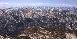
 Part of the Bitterroot Range in Montana, looking north from El Capitan peak | |
| Highest point | |
| Peak | Trapper Peak |
| Elevation | 10,157 ft (3,096 m) |
| Coordinates | 44°21′14″N 112°49′17″W / 44.353807°N 112.821407°W |
| Dimensions | |
| Length | 304 mi (489 km) N/S |
| Width | 268 mi (431 km) E/W |
| Area | 14,742 sq mi (38,180 km2) |
| Geography | |
| Country | United States |
| States | Idaho and Montana |
| Parent range | Rocky Mountains |
The Bitterroot Range is a mountain range and a subrange of the Rocky Mountains that runs along the border of Montana and Idaho in the northwestern United States. The range spans an area of 24,223 square miles (62,740 km2) and is named after the bitterroot (Lewisia rediviva), a small pink flower that is the state flower of Montana.[1][2]
- ^ "Bitterroot Range". Canadian Mountain Encyclopedia. Bivouac.com. Retrieved 4 March 2007.
- ^ "Bitterroot Mountains". PeakBagger. Retrieved October 13, 2012.
